 Aerial Views of Mt Whitney - are a great help in getting to know Mt Whitney and the surrounding area in a way that is impossible while on the ground. Thanks to my climbing partner's Lightweight Sport Aircraft we at Timberline Trails are able to offer our readers the ability to step back and see Mt Whitney from a whole new perspective.
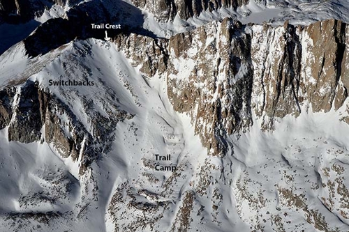 To the right you see
Above you see
an image taken in March of 2014 showing Trail Camp, the Switchbacks, and Trail Crest from the air during the winter.
To the right you see
Above you see
an image taken in March of 2014 showing Trail Camp, the Switchbacks, and Trail Crest from the air during the winter.Climbing Mt Whitney during the winter months is quite a challenge due to extremely cold temperatures and deep snow. The new snow has not had a chance to compact, and thus, snowshoes and other winter gear is a must in order to make any kind of decent progress. But once spring comes, the snow is much firmer and crampons and ice ax become the order of the day and travel can sometimes be even easier than in the summer months when you have to contend with loose rock.
 In the aerial image
to the left,
above,
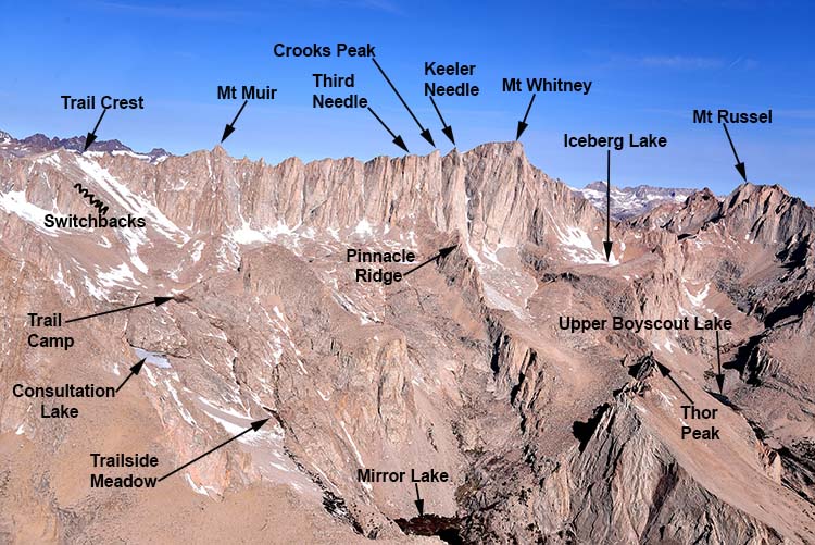
you see all the major landmarks on the East Side of Mt Whitney. Mirror Lake is at the low point in the photo. It is located 4 miles from the Trailhead at 10,640 feet above sea level. There is not camping at this lake due to restorative efforts.
In the aerial image
to the left,
above,
you see all the major landmarks on the East Side of Mt Whitney. Mirror Lake is at the low point in the photo. It is located 4 miles from the Trailhead at 10,640 feet above sea level. There is not camping at this lake due to restorative efforts.About a mile from Mirror Lake at 11,400 feet, you come to Trailside Meadow. No camping here either, but a great place to take a break.
Next we come to Consultation Lake and Trail Camp. Most people make these areas their high camp before going to the summit. Trail Camp is located 6 miles from the Trailhead at 12,000 feet. After Trail Camp, you are faced with the infamous 99 switchbacks. Fair amount of work to get up this section of the peak, and is one of the areas that fills up with snow and ice early on in the late fall and winter months. Then we come to Trail Crest, 8.2 miles from the Trailhead at 13,700 feet above sea level. The view from Trail Crest affords one of the most beautiful views in all the Sierra Nevada. Not far from Trail Crest you will pass the cut off scramble to the top of Mt Muir. As described in our page on the Mt Whitney Trail, bagging Mt Muir from the backside of the Mt Whitney Trail is an easy way of picking up another 14er if you have the skills to climb a class three rated peak. From there, its only a couple more miles or so to the Summit of Mt Whitney.
On the right side of the above aerial photo, you see a great view of the North Fork of Lone Pine Creek. Climbers who are taking on Mt Whitney's East face routes this approach for access. It is a much more demanding trail and gets fairly faint in some sections as you scramble over boulders and loose rock, but it is by far the most direct route if you plan on doing the Mountaineer's Route or one of the East Face Climbs. Upper Boyscout Lake or Iceberg Lake are great places to setup camp for for East Face adventures. Lastly, you see Mt Russel in the upper right hand portion of the above image. It is another Sierra 14,000+ foot peak, and is a worthy goal for Mountaineer's and climbers of all skill levels.
 In the image
to the right
above
you see an aerial photo that I took with a telephoto lens from an altitude of approximately 14,600 feet. It gives a good layout of Consultation Lake and Trail Camp. Some people camp at Consultation Lake and it is certainly a bit more remote and less crowded than Trail Camp, but Trail Camp has many more established sites for setting up your tent and it is better located for quick access to the trail for your morning attempt on the summit.
In the image
to the right
above
you see an aerial photo that I took with a telephoto lens from an altitude of approximately 14,600 feet. It gives a good layout of Consultation Lake and Trail Camp. Some people camp at Consultation Lake and it is certainly a bit more remote and less crowded than Trail Camp, but Trail Camp has many more established sites for setting up your tent and it is better located for quick access to the trail for your morning attempt on the summit.You also can see the little tarn (small lake or pool) which is the last reliable water source before going to the summit. During the busy summer months, Trail Camp can gain the appearance of a small city of tents, so you will not want for company that's for sure. It is located at 12,000 feet, so you will feel the altitude when sleeping or walking about.
Lots of people once they get to this camp just set up their tent and try to get some rest by lying down inside. I find that this can be counter productive when it comes to getting altitude sick. It is best to keep active doing camp chores and other activities. This helps you acclimate better. For more on this subject, please visit our page on Altitude Sickness.
 In the photo
to the left
above
you can see the layout of the infamous 99 switchbacks leading to Trail Crest.
In the photo
to the left
above
you can see the layout of the infamous 99 switchbacks leading to Trail Crest. This aerial photo was taken in mid-spring, and people were using the snow patch for a quick descent down this section of the peak. An ice ax would be a must here, but there is the danger of hitting rocks on the way down.
If you choose to do this type of activity, make sure you have the experience, and if not, practice the art of Glissading in areas where you have a safe run-out (just in case things get a bit out of control).
To go from Trail Camp to Trail Crest you will gain 1,738 feet of elevation. It is a steep run, but the numerous switchbacks (as mentioned above) divide the work load up nicely. During the summer months some parties try and save some time by short cutting the switchbacks. But in my experience of watching people do this, they actually loose time in the end and end up working much harder than they would have if they would have just stuck to the trail (not to mention the fact that this is against the forest service rules and regulations).
 Next we see an aerial view of Trail Crest and Guitar Lake. Trail Crest is located 8.2 miles from the Trailhead at an elevation of 13,700 feet. Once there, you will notice a sign that informs you that you are entering Sequoia National Park. The view from this vantage point is nothing short of spectacular and arguably could be considered one of the most beautiful scenes in the entire Sierra Nevada Range.
Below Trail Crest you see well named Guitar Lake in Sequoia National Park located at an elevation of 11,500 feet (2,200 feet below Trail Crest). This is where most hikers and backpackers set up camp on the Sequoia side for attempts on Mt Whitney. Like Trail Camp, Guitar Lake is the last reliable source of water before setting off for the summit of Mt Whitney. High Altitude really sucks the moisture out of you, so make sure to fill up your water bottles or other water carrying storage devices before taking of for the top. I have seen several people over the course of the years (including myself) run out of water and end up having to borrow it from other hikers or go without. Getting dehydrated can sap your energy and increases your chance of becoming altitude sick, so carry enough for your needs. For more on this subject please visit our page on Water/Dehydration.
 Once past Trail Crest, you have the 2.8 mile trek to the Summit on the back side of Mt Whitney. For much of this last section of the trail you will be hiking at elevations above 14,000 feet.
There is not too much elevation gain between Trail Crest and the summit, but the thin air will make up for it when it comes to taxing your lungs.
In the aerial photo to the left above you can see Muir Junction (labeled in green). This is where the John Muir Trail hooks up with the Mt Whitney Trail. For those doing the John Muir Trail that starts in Yosemite National Park, you are almost done. Only a couple of miles to go of the 210+ mile journey from Yosemite's Happy Isles trailhead.
The John Muir Trail takes one through some of the finest backcountry wilderness in the world that culminates on the summit of Mt Whitney. It also shares a common footpath with the Pacific Crest Trail for 160 miles of it's length.
 To the right
Above
you see an image on Mt Muir that I took while flying with my climbing partner at about 13,000 feet. Climbing Mt Muir from the Mt Whitney Trail is the easiest way of reaching the summit. It stands at 14,015 feet and therefore qualifies as one of California's 15 14ers.
To the right
Above
you see an image on Mt Muir that I took while flying with my climbing partner at about 13,000 feet. Climbing Mt Muir from the Mt Whitney Trail is the easiest way of reaching the summit. It stands at 14,015 feet and therefore qualifies as one of California's 15 14ers.It is a class three climb to the summit, so if you are not comfortable with this type of terrain you should not attempt it. But if you are, it is an easy way to bag another 14er along with Mt Whitney.
The route to the top of Mt Muir via the trail starts at about 500 yards from the Muir Junction (as shown in the photo above). Once you leave the trail you will be faced with a short scramble over large talus that bumps you up against the west face of the peak. Here you will have about a hundred and fifty feet to gain on class three rock. The yellow line shows the path. You can take either the right of left chimney on the face, depending on which you are more comfortable with. There is a bit of exposure going up this last section, so I would recommend that you carry a short length of rope (about 60 feet or so) and a couple of pieces of protection. This should ease your nerves a bit if you are not super comfortable with class three climbing. But as mentioned above, if you are an unexperienced climber you should not attempt the peak.
 In the photo above (that my climbing partner Mike Koerner took from his sail plane), you see a view looking south from just a bit north from Mt Russell. In the distance you can see Olancha Peak that rises up to an elevation of 12,132 feet. After that we have Mt Langley at 14,042 feet. Mount Langley is another great peak to climb just south of Mt Whitney. The access trail is beautiful as it winds through the Cottonwood Lakes Basin.
After Mt McAdie we have Mt Muir as discussed above and then Mt Whitney. Pinnacle Ridge is an interesting landmark since it blocks easy passage from the Mt Whitney Trail to the North Fork of Lone Pine Creek. I remember years ago when I thought I could just take the trail to Trail Camp, and then traverse over to get into position to climb one of the East Face Routes. I was met with a surprise when I finally reached the top of the ridge and swung my leg over the top. My eyes got as big as saucers as I peered down a sheer drop of several hundred feet. Needless to say I quickly went back down to the trail and called it a day.
 Here we have another aerial photo taken by Mike from his sail plane way above the summit of Mt Whitney. If you look closely you can see the summit hut. Note Keeler Needle to the right of Mt Whitney. It stands at 14,260 feet and has it's own Summit Register. But it is not counted as it's own peak due to the fact that it does not meet the requirements.
The UIAA definition is that a summit qualifies as independent if it has a prominence of 30 meters (98 ft) or more; it is a mountain if it has a prominence of at least 300 meters (980 ft). Keeler Needle therefore qualifies as a summit but not it's own mountain. For that matter, Mt Muir also by definition only qualifies as a summit (because it does not vary in elevation by more than 980 feet, but most folks consider it to be a mountain.
Other prominent features are Iceberg Lake where many climbers set up camp for East Face Routes, and the North Fork of Lone Pine Creek which is the access basin that people use to get to Iceberg Lake and the Lower and Upper Boy Scout Lakes. Also you see the Mt Russell Ridge Line that most climbers use to gain the summit of Mt Russell.
 Moving along we see another aerial photo I took showing the tops of Keeler Needle, Crooks Peak, (formally known as Day Needle) and Third Needle (along with Mt Whitney in the background).
Now for a little history. Hulda Hoehn Crooks (May 19, 1896 – November 23, 1997) was an American mountaineer. Affectionately known as "Grandma Whitney" she successfully scaled 14,505-foot Mount Whitney 23 times between the ages of 65 and 91. She had climbed 97 other peaks during this period. But in 1990, by an Act of Congress, Day Needle (one of the peaks in the Whitney area), was renamed Crooks Peak in her honor. In 1987, at the age of 91, she became the oldest woman to complete the ascent of Mt. Fuji in Japan.
She hiked the entire 212 mile John Muir Trail in the high Sierras, completing the hike in segments over five years. Hulda Crooks was a long-time resident of Loma Linda, California and a Seventh-day Adventist. She often spent time with children in the community, encouraging them to appreciate nature and stay active. In 1991 Loma Linda dedicated a park at the base of the south hills as "Hulda Crooks Park." Hulda explained her life at 80 this way: “Early to bed and early to rise. Out jogging about 5:30am. Jog a mile and walk it back briskly. It takes me 12 minutes to jog the mile and 15 minutes to walk it. Do some upper trunk exercises, work in the yard, walk to the market, and to work."
Congressman Jerry Lewis of California (one of her hiking companions), tells us: “No mountain was ever too high for this gentle giant. With a twinkle in her eye, and purpose in her step, 'Grandma Whitney' showed the world that mental, physical and spiritual health is attainable at any age.” (The above article on Hulda Crook is from Wikipedia)
Below to the right we see an aerial photo from about 500 or 600 feet above the summit. In the photo to the left, you can see highway 395 snaking through the Owens Valley over 10,000 feet below. Also in the photo below right, you can see an even closer view of the summit hut as we made another pass over the summit at a lower elevation with Mike's Lightweight Sport Aircraft.


Above is an Aerial Photo that I took on an early spring flight from the northeast of Mt Whitney. It gives you a great view of Tulainyo Lake. Tulainyo Lake is located at an elevation of 12,828 feet above sea level and it is one of the highest lakes in the contiguous United States. It is situated between the following four peaks, Mount Russell, Tunnabora Peak, Mt Carillon, and The Cleaver. Due to the fact that this high altitude lake sits in the shadow of the aforementioned peaks, it remains pretty much frozen well into the early summer and then refreezes in the early fall. It is a beautiful site for the climber on Mt Russell or from the air as shown here. Also, note the multiple peaks in the background that create the grandeur of Sequoia National Park. One thing for sure is that the backpacker/climber will never run out of things to do in the Sierra Nevada.

This next aerial photo (above) was taken from from Mike's Lightweight Sport Aircraft on October 20th, 2014. Here we see a classic view of Mt Whitney, Mt Muir, and all the Needles. You also see Trail Crest and the switchbacks leading up to it under heavy snow. Also check out Pinnacle Ridge. As mentioned above, I tried to reach the East Face Routes coming from Trail Camp many years ago, only to be turned back after reaching the ridge and looking down the near sheer cliffs on the north-side of the divide.
 Finally we have a clear Aerial Photo that I took in mid-spring showing the Whitney Region. Here we can see the terrain from Trail Camp to Trail Crest and a view of Sequoia National Park and the surrounding peaks looking northwest. It also gives you a great view of Iceburg Lake and the Whitney Russell Pass. If you decide to descend Mt Whitney going down the North Slope of the peak and you are camped near Iceburg Lake of further below, then Russell Pass is your key to getting back on the East Side of Mt Whitney. For much more on this Route, see our page on the Mountaineer's Route.
It is our hope that this page has given you a wonderful look into the Whitney Region from the air, and that it will be of help to you when planning your up and coming wilderness outings. For much more on hiking and climbing in this extremely popular area of the Sierra Nevada, click on the above menu and choose the Mt Whitney option for another adventure on wonderful peak!
Email Sign Up

|
Join the Adventure! Sign up here for Timberline Trails Monthly Newsletter |

Join us on Instagram
©2006-2026 TimberlineTrails. All Rights Reserved.
....