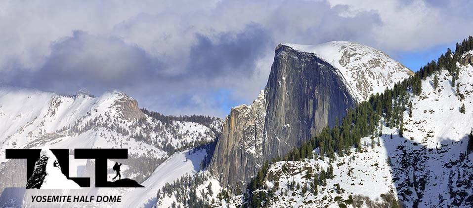
 Half Dome is by far the most well known and photographed of all the High Sierra smooth granite domes. Rising nearly 4,800 feet above the valley floor, its sheer Northwest Face is an inspiring site for the multitudes of visitors to Yosemite Valley. In the year that the Civil War ended in 1865, the California Geological Survey reported the following after viewing the imposing site of Half Dome. "It is a crest of granite... perfectly inaccessible, being probably the only one of the prominent points about the Yosemite which never has been, and never will be, trodden by human foot." But just a short 10 yeas later in the month of October in 1875, George Anderson reached the summit by drilling and placing iron eye bolts into the smooth granite to assist him in his success (he placed the eye bolts about every 5 feet or so, and then stood on his last bolt placement, while drilling in the next). Later, in 1919, his method was adopted by the Sierra Club who placed a pair of post-mounted steel braided cables near Anderson's original route. Today, this setup is known as the Half Dome Cable Ladder Route.
Each year in the month of May or early June, the Yosemite Rangers set up the uprights and place 2x4's across them to provide a resting spot for hikers ascending the dome. Then in late October, the uprights are taken down, and the cables are laid to rest flat against the granite. This is to discourage attempts up this route during the off-season months.
Unlike the past, all people using the Half Dome Trail above the subdome must have a permit in possession 7 days a week. A maximum of 300 permits will be issued each day (225 permits are for day hikers, and 75 for backpackers). The park service has also instituted a lottery process. There is the pre-season lottery in March, but after the cables are put up, a lottery is conducted each day. During the pre-season lottery, you can apply for a permit for 6 people and choose 7 dates to try for. Above Info from the Yosemite NPS For more information on Getting a Half Dome Permit Click Here
 Of all the hiking possibilities in and out of Yosemite Valley (arguably) Half Dome is the most exciting. I know of no other trail in Yosemite, that has the combination of such beautiful land and water scenery, incredible trail engineering and yes, the adventure of a 400 foot vertical gain on a 45 degree slope up smooth granite via a cable ladder.
All the above makes Half Dome a "must do hike" for all those who are willing (and capable of) putting in the necessary hard work to gain its 8,800 foot summit.
Your hike up Half Dome starts at shuttle stop #16 in an area known as "Happy Isles" located in the eastern end of Yosemite Valley. But before we get started, there are a few things you need to think about. First, how about your physical condition? The Yosemite Visitors Guide describes the Half Dome hike as the most strenuous day hike in all of Yosemite. You will be traveling on foot anywhere between 14 to 16.3 miles round trip (depending on which trail you take), and gaining nearly 4,800 feet of elevation. Needless to say, it is a serious hike. Most folks who are successful in making the summit take between 10 to 12 hours to complete the it, so you will need to set a day aside to make your attempt. Next, is whether you are subject to Altitude Sickness at moderate elevations. If so, you will need to take a bit more time to acclimate.
If the above seems a bit intimidating, or if you have younger folks along, there is the option of backpacking up to "Little Yosemite Valley," camping there, and then completing your summit bid on Half Dome in the morning. This splits up the hike into about two equal parts. This approach would make things a lot easier if you are not quite up to a single push to the summit. If you adopt this method of attack you will need a wilderness permit for an overnight stay in Little Yosemite Valley. You will also need to protect your food (and ultimately the bears) by carrying a bear box (required), because bears certainly frequent this area of Yosemite.
 Above Topo Map Used by Permission from National Geographic
 After considering your Physical Conditioning and your ability to hike at moderate altitude, you will also need to plan for what you are going to take along on the hike. I would recommend a good pair of lightweight hiking boots with a sole that affords a good grip on the rock. This is not only important for the trail, but will be much more important when it comes to your travel up the smooth granite on Half Dome can be a good 15 degrees cooler than
the valley floor, and it can be a whole lot windier up there, so plan accordingly. I would also carry a decent day pack with food and a gallon of water. It is very easy to get dehydrated in the mountains, and running out of water is no fun (and can be
dangerous) when it comes to any outdoor endeavor. For more on this subject, please visit our page on Water/Dehydration.
After considering your Physical Conditioning and your ability to hike at moderate altitude, you will also need to plan for what you are going to take along on the hike. I would recommend a good pair of lightweight hiking boots with a sole that affords a good grip on the rock. This is not only important for the trail, but will be much more important when it comes to your travel up the smooth granite on Half Dome can be a good 15 degrees cooler than
the valley floor, and it can be a whole lot windier up there, so plan accordingly. I would also carry a decent day pack with food and a gallon of water. It is very easy to get dehydrated in the mountains, and running out of water is no fun (and can be
dangerous) when it comes to any outdoor endeavor. For more on this subject, please visit our page on Water/Dehydration.Over the years, I have found that carrying a day pack in the form of a "Camel-bak" is the best way to carry water. Having a tube right there available to sip on at any time is the best way to stay properly hydrated. I would also carry a map, compass, and headlamp just in case. Not a whole lot of chance of getting lost (with the multitudes of people on the trail) but it is just plain good practice to carry these items. A headlamp is a must, because you never know how things will unfold.
 If something goes wrong, or if you have overestimated your abilities and get caught out there in the dark, a headlamp would become a vital piece of equipment for enabling you to get back down the trail.
Lastly, you may want to consider taking a pair of gloves for gripping the cables on the last section of the climb to protect your hands. If you are somewhat apprehensive when it comes to heights and falling, I would recommend having a climbing harness, a couple of carabiners, and some webbing to attach yourself to the cables as you ascend. This will add a good deal of protection if you apply the gear properly.
The above would be my recommendations for what to take along. But ultimately, you have to make your own choices and be responsible for them. The next order of business is deciding which trail you will take (The Mist Trail, or the John Muir Trail). From the Vernal Fall Footbridge (above photo) you will be able to get a beautiful view of Vernal Fall (left). After the footbridge, the trail then divides. The fork to the left takes you up the Mist Trail, and the one to the right takes you up the John Muir Trail.
 So which trail do you take? Here are a few considerations. The Mist Trail is shorter in distance, but it is not necessarily faster. I find that it depends on how many people are on the trail at any given time, and how comfortable you are at ascending large uneven granite steps.
If you consider the trail mileages listed below, it would seem best to take the Mist Trail. But as mentioned above, there are other factors involved. Firstly, the crowds. If there are a lot of people on the trail (like on the weekends) things can grind to a halt. The Mist Trail is very steep, and it gets very narrow in sections. When this happens, it is inevitable that you are going to run into people that are very uncomfortable with the steep narrow granite stairways that frequent many sections of the trail. When this happens people can either end up blocking the trail for a portion of time, or will continue at a painfully slow pace (at best). This can impede your progress considerably. Getting around people who are in this fearful condition is not easy, and doing so could create a dangerous situation if you force your way around them on the trail (not to mention the poor backcountry etiquette of doing so).
Trail Facts
Mist Trail - 14 miles round-trip
John Muir Trail - 16.2 miles round-trip
Mist Trail up and John Muir Trail down - 15.1 miles

So......which trail do you take?
If you want to take the Mist Trail for as part of your experience in doing Half Dome, then the following would be my
recommendations.
1) Get an early start (no matter which trail you take). Most people who are out for a nice hike on the Mist Trail do so in the later morning hours. By that time you are long gone. On top of all this, most of the trouble occurs when people are coming down the Mist Trail.
This happens in the early to late afternoon hours.
2) Therefore, do not use the Mist Trail for your descent back into the valley from Half Dome if you are in a hurry. Even though the Mist Trail is shorter in distance when compared to the John Muir Trail, it is much less crowded and it is much smoother going.
You can make quick work of it if necessary (especially when going down).
3) Lastly, taking the John Muir Trail for both your ascent and decent is also a good option if you want to skip the Mist Trail altogether.
 In conclusion, if you have never hiked the Mist Trail, I would highly recommend it. It is more exciting than the John Muir Trail (when
going from the Yosemite Valley floor to the Half Dome cut off trail), and the views along the way (especially of Vernal and Nevada Falls) are hard to beat. Additionally, even though the Mist Trail is shorter in distance, it is more arduous than the John Muir Trail, due to the many steep stair sections composed of uneven granite blocks.
In conclusion, if you have never hiked the Mist Trail, I would highly recommend it. It is more exciting than the John Muir Trail (when
going from the Yosemite Valley floor to the Half Dome cut off trail), and the views along the way (especially of Vernal and Nevada Falls) are hard to beat. Additionally, even though the Mist Trail is shorter in distance, it is more arduous than the John Muir Trail, due to the many steep stair sections composed of uneven granite blocks.
 If you are in excellent condition, the steep steps can help you gain altitude very quickly. If this sounds troubling, then you may be better off with the John Muir Trail (however, if you are uncomfortable on the Mist Trail,
you will be absolutely terrified on the Half Dome cable ladder).
If you are in excellent condition, the steep steps can help you gain altitude very quickly. If this sounds troubling, then you may be better off with the John Muir Trail (however, if you are uncomfortable on the Mist Trail,
you will be absolutely terrified on the Half Dome cable ladder).So after weighing in all the facts, the John Muir Trail turns out to be the faster of the two trails. I have been up both trails several times, and I can safely say that the John Muir Trail is the quicker option of the two. In the above photo you can see what a beautiful image of Nevada Falls is possible when hiking along the JMT. This (and the further up smaller two photos) are some of the views that you will experience while traveling along the John Muir Trail.
 For much more on the Mist Trail,
please check out our write up on this beautiful pathway by Clicking Here.
For much more on the Mist Trail,
please check out our write up on this beautiful pathway by Clicking Here.At the top of Nevada Falls the Mist Trail ends by joining the John Muir Trail. From there you will continue on it until you reach the Half Dome junction cutoff trail.
The photo to the left shows a couple of the Merced River tributaries joining up before cascading over Nevada Falls as shown in the image below.
You do not want to play around in the water here. If you should loose your footing the consequences would be dire. Over the years, people have gone over the falls and to their deaths as a result of not having respect for the fast moving water.

 Once past Nevada Falls, you are at about at the halfway point in terms of distance. The trail marker in the in the upper left image, informs you that you have 4.5 miles to go. However, these last half of the hike is the most difficult.
That being said, you do get a small break in the very beginning (after reaching the top of Nevada Falls) while doing the short hike (on fairly level ground) as you pass through the Little Yosemite section of the trail as shown in the left hand image.
There are plenty of good spots to set up a tent here, and there is also a restroom available. Combined with the restroom, is a little ranger station (but the Ranger Station is not alway manned).
 Little Yosemite Valley is the last official camping area before making your push to the top of Half Dome.
The park service also posts a sign to let you know that camping above 7,600 feet is prohibited on the Northeast Shoulder of Half Dome (as well as camping on top).
Many years ago on my first trip to the top of Half Dome, I noticed a few campers all set up on the summit of Half Dome. A cool idea, but for reasons as stated in the notice to the right, this is no longer allowed.
After exiting Little Yosemite Valley, your progress will turn upward and you will pass through a beautiful forested area as shown in the image below.

 About midway between Little Yosemite Valley and the top of Half Dome, you come to the junction where you will leave the John Muir Trail and proceed up the Half Dome cut-off trail. This trail takes you to the base of the domes cable ladder. It is about a 2 miles hike that will take you through some very steep terrain.
Once you get to the base of the Sub-dome, you will be greeted with the sign (shown in the below left hand image) notifying you that proceeding past this point during or after a lightning or rain storm could be fatal.
I have to say that most deaths on Half Dome are a result of people ignoring this warning sign. Several people have been killed as a result of lighting, and others have slipped and fallen to their deaths on the cable ladder section due to wet conditions. No summit is worth that!

 Climbing the Sub-dome of Half Dome entails a steep section of granite steps as shown in the above right and left hand photos. There is very little if any handrails to take hold of and care must be taken so you do not trip (especially on the way down).
Falling here could result in a nasty injury or worse. Also, be considerate of others, and do not try and push your way around people. Doing so would certainly create unnecessary danger to all involved.
At the base of the Sub-dome, you have 900 vertical feet to gain. Five hundred of the 900 feet are on the Sub-dome and the remaining 400 feet will be gained on the Half Dome Cable Ladder.
In the below left photo, you see my son Ben looking down the Sub-dome section. Note the considerable amount of elevation gain in such a short distance. This part of the climb will surely take the wind out of you if you go too fast.

In the distance (looking in the opposite direction of the main dome as seen in the above right hand image), you can see a group of people on top of the Sub-dome.
 Now moving ahead, you will finally arive at the base of the infamous cable section of your Half Dome adventure. Check out the slope just to the right of
the cables. It gives you a good idea of just how steep this portion of the climb is.
Now moving ahead, you will finally arive at the base of the infamous cable section of your Half Dome adventure. Check out the slope just to the right of
the cables. It gives you a good idea of just how steep this portion of the climb is.
It is a 400 vertical foot elevation gain laid out along a 45 degree slope of hardened granite. Some hikers choose to call it a day at this point, and if you are afraid of heights, this part of the climb can certainly be intimidating!who are afraid of heights.

In the left and right photos above, you can see the difference in traffic based on the time of day. Our mid June trip to the top of Half Dome was done on a Saturday (weekends in Yosemite are very crowded). We started from the Yosemite Valley floor at 4:00 AM, and reached the base of the cables at 8:30 AM. The view to the left shows you the traffic at 8:30AM in the morning, and then later (after ascending and spending about an hour on top), we began our decent. This took place at 10:30AM. Check out the difference in the foot traffic in the photo to the right vs the one on the left. Needless to say, it pays to get an early start.
But if you do get caught in a traffic jamb on the cables, you need to remain calm and proceed as best and safely as possible. Even though you may see a few brave souls (or foolish ones) moving outside the cables, this is not recommended. Should anything go wrong, you will have little to stop you from falling all the way to the bottom (and most likely to your death). You will also loose the aid of the 2x4's, that provide for a nice little rest stops when needed. The granite rock is pretty slick, and as mentioned in the beginning, good gripping soles on your footwear can make all the difference.
 At the base of the cable ladder is a pile of old gloves. Many hikers spend lots of time rummaging through them (trying to find a pair that both fits and are not to grungy).
The park service is not to keen on hikers leaving their gloves behind to rot at the base of Half Dome, but nevertheless, the practice continues.
We brought our own gloves, and also packed them out. My two sons used theirs, but I found it best (personally) to go up the cables without them. I got a better grip that way. But if your hands are somewhat soft, then you will want to use a pair of gloves.
The cables are capable of producing some good sized blisters if you hands are not up to the challenge. Also bringing your own gloves saves lots of time by not having to search through the pile for gloves that fit you.
 In the above photos you can see what a difference an hour can make on a busy spring or summer day on the Half Dome Cables,
and what complicates this whole situation even further is that those ascending are now running into hikers who are descending the cables. It is in situations like this, that people are tempted to go outside the cables (but don't give in to the temptation). Thus, as mentioned above, getting an early start is very important if you want to avoid a traffic jam.
Now for a little history
In the above photos you can see what a difference an hour can make on a busy spring or summer day on the Half Dome Cables,
and what complicates this whole situation even further is that those ascending are now running into hikers who are descending the cables. It is in situations like this, that people are tempted to go outside the cables (but don't give in to the temptation). Thus, as mentioned above, getting an early start is very important if you want to avoid a traffic jam.
Now for a little historyAs mentioned in the beginning of this article, George Anderson was the first to climb Half Dome. James Hutchings, who witnessed Anderson's epic first ascent up Half Dome wrote the following account in "The Heart of the Sierras"
Until the fall of 1875 the storm-beaten summit of this magnificent landmark [Half Dome] was a terra incognita, as it had never been trodden by human feet... This honor was reserved for a brave young Scotchman, a native of Montrose, named George G. Anderson, who, by dint of pluck, skill, unswerving perseverance, and personal daring, climbed to its summit; and was the first that ever successfully scaled it. This was accomplished at 3 o'clock P. M. of October 12, 1875.
The knowledge that the feat of climbing this grand mountain had on several occasions been attempted, but never with success, begat in him an irrepressible determination to succeed in such an enterprise. Imbued with this incentive, he made his way to its base; and, looking up its smooth and steeply inclined surface, at once set about the difficult exploit. Finding that he could not keep from sliding with his boots on, he tried it in his stocking feet; but as this did not secure a triumph, he tried it barefooted, and still was unsuccessful. Then he tied sacking upon his feet and legs, but as these did not secure the desired object, he covered it with pitch, obtained from pine trees near; and although this enabled him to adhere firmly to the smooth granite, and effectually prevented him from slipping, a new difficulty presented itself in the great effort required to unstick himself; and which came near proving fatal several times.
Mortified by the failure of all his plans hitherto, yet in no way discouraged, he procured drills and a hammer, with some iron eye-bolts, and drilled a hole in the solid rock; into this he drove a wooden pin, and then an eye-bolt; and after fastening a rope to the bolt, pulled himself up until he could stand upon it; and thence continued that process until he had finally gained the top—a distance of nine hundred and seventy-five feet! All honor, then, to the intrepid and skillful mountaineer, Geo. G. Anderson, who, defying and overcoming all obstacles, and at the peril of his life, accomplished that in which all others had signally failed; and thus became the first to plant his foot upon the exalted crown of the great Half Dome.
 Half Dome has a very large summit indeed. I have read estimates of anywhere between 5 to 7 acres in total (and I thought Mt Whitney had a large summit area).
Needless to say, we did not make any real assessment of the acreage, but rest assured there is plenty of room up there for any size group that you can reasonably imagine (with plenty of room left over for several games of football).
On a nice day, you can take quite a stroll on Hald Dome's summit plateau. This is another reason why you want to get an early start on Half Dome. Getting on top early gives you the extra time to enjoy the many views and the large summit area of Half Dome (that's if you have any energy left over after the long hike to the top).
 While walking about on the large flat summit of Half Dome, you will find that some people have put in a good deal of effort to construct some pretty elaborate cairns. Usually we find just a simple stack of rocks marking the summits (here and there) in the Sierra Nevada. But people have gone a little overboard here. Not much chance of getting confused as to whether or not you are on the top of Half Dome.
Years ago people used to camp on the top of Half Dome (plenty of room to do so). But today this is prohibited (as mentioned above). Not only did the campers cut down six of the seven trees, that grew on the summit of Half Dome, but the volume of human waste became another overwhelming problem to contend with.
 Looking Southeast from the summit of Half Dome you see several very well known peaks of the Sierra Nevada. Mt Ritter being the most distant here is the highest peak in Madera County at 13, 157 feet above sea level. It is located in the Ansel Adams Wilderness, and along with Yosemite, it is one of the finest backpacking areas in all of the Sierra Nevada.
Another interesting peak is Mt Clark located in the Southern end of the park. The peak was first climbed in 1866 by Clarence King and James Gardiner of the US Geological Survey via the class 3 Southeast Ridge. Mt Clark's summit stands at 11,522 feet above sea level.
 The Lyell Fork of the Merced River with its high remote peaks (as shown in the photo to the right) was among Ansel Adam's favorite areas in Yosemite.
The peak was subsequently climbed for the first time in 1934 by Glen Dawson, Jack Riegelhuth, and Neil Ruge. Two days later, they led a Sierra Club party of fifteen (which included Adams and his wife Virginia) up to the top of the peak. On the summit, they dedicated the peak to Adams.
Later that evening, they agreed that the peak should be called Adam's (after the leader of their expedition). But the problem was that the U.S. Geological Survey did not permit naming features after living individuals. So the peak did not officially become Mt. Ansel Adams until 1985, a year and one day after his death (before that the peak was known as The Tower in Lyell Fork).
 Now looking Northeast, we see the peaks that are located in Tuolumne Meadows come into view.
One of the most interesting here is North Peak. This 12,242 foot peak is very accessible from the road and the peaks fine couloirs are very popular among ice climbers.
You can get to the base of North Peak from the road in less than a half day, and you will pass through some of the most beautiful pristine meadows in all the Sierra Nevada.
If you are not into ice climbing, there are other non-technical routes up the peak, and you will not be disappointed if you choose to hike or climb to the top of North Peak.
 Check out the incredible view in the photo to the right looking straight down into Yosemite Valley 4,800 feet below. Climbing the sheer Northwest Face of Half Dome has to be a real adrenalin rush.
The first technical ascent was in 1957 via a route pioneered by Royal Robbins, Mike Sherrick, and Jerry Gallwas. The route they took is now known as the Regular Northwest Face.
Their 5-day epic climb was the first Grade VI climb in the United States. Warren Harding had hiked up the backside of Half Dome via the hikers trail for the occasion. Harding, Mark Powell, and Bill Feuerer, were also planning a first ascent of the Northwest Face, but they were beaten to the punch as described above. Nevertheless, Harding offered the winning team a warm congratulations.
Todays elite Yosemite climbers, can scale the face in a matter of two hours or less. It seems incomprehensible to me that anyone can achieve this kind of speed on such a difficult route.
 After an enjoyable stay on the summit of Half Dome, now comes the task of getting down. After a fairly quick climb to the top (under less crowded conditions), things have now changed.
There is a fair amount of traffic coming up, and this is when things get a bit interesting.
In order to keep things moving, both parties must now move to one side or the other in order for passing to take place.
Patients is needed here, because being in a hurry can create additional danger. So take your time and enjoy the view.
Notice that the cables seem to disappear off the cliff in the distance. But take heart, as you progress, all things will come back into proper perspective.
SUMMARY:
After an enjoyable stay on the summit of Half Dome, now comes the task of getting down. After a fairly quick climb to the top (under less crowded conditions), things have now changed.
There is a fair amount of traffic coming up, and this is when things get a bit interesting.
In order to keep things moving, both parties must now move to one side or the other in order for passing to take place.
Patients is needed here, because being in a hurry can create additional danger. So take your time and enjoy the view.
Notice that the cables seem to disappear off the cliff in the distance. But take heart, as you progress, all things will come back into proper perspective.
SUMMARY:
- Half Dome is arguably the most adventuresome day hike in Yosemite. The trails that lead to the cables section of Half Dome, navigate through some of the most beautiful terrain to be seen anywhere on earth.
- The park service considers the Half Dome hike to be the most strenuous day hike in all of Yosemite National Park.
- There are two trails that lead to the top of Half Dome. You can take either the Mist Trail or the John Muir Trail to accomplish your goal. Each has its advantages and disadvantages. The Mist Trail is shorter (14 miles round trip vs 16.2) and is more scenic in the opinion of most visitors. But the downside is that it is more strenuous due to the fact that you gain elevation faster due to the many large granite steps. The other downside to the Mist Trails is that it becomes congested by late morning and this turns it into the slower route when compared to the John Muir Trail. So if you are in a hurry, the JMT may be your best bet. If not, then the Mist Trail is a good option for its scenic beauty (this is not to say that the John Muir Trail is not beautiful).

- If you have younger folks along (or if you are not in quite the physical shape you would wish), then you may want to consider camping at the half-way point at Little Yosemite Valley to make things easier.
- Make sure to bring a good day pack with at least a gallon of water, unless you bring a water filter to replenish your supply along the way. Also bring a lunch to munch on. Dress properly for the current or potential weather conditions. Layering works best. Remember, the top of Half Dome can be between 15-20 degrees F cooler then the Valley Floor below. And make sure to bring a headlamp with you, just in case things do not turn out the way you expect. This way you will have a light source to enable you to get down.
- Make sure to get an early start. The average hiker takes between 10-12 hours to make the round trip from the Valley Floor. Starting early helps you avoid the crowds. We started at 4:00 AM (with headlamps) and were able to make the top, spend some time there, and then get back down to Happy Isles by 1:30 PM. We used the John Muir Trail both ways (since just a month earlier, we went up the Mist Trail). An early start has a lot going for it.
- Do not attempt to climb Half Dome if the cables are down, lightning is a threat, or if a storm is on the horizon. Signs warn you of this, and it is just plain common sense to abandon your climb under these conditions. I have heard stories of people who died attempting to go to the top of Half Dome with the cables down, and have heard of several deaths due to lightning. On top of this, there have been at least 5 hikers who fell to their deaths while on the cable ladder as a result of wet slippery conditions during or just after a rain. The last death reported was just a week before we hiked to the top of Half Dome in June of 2009. A hiker apparently slipped on the wet granite going up the cables just after a rain storm. Again, do not attempt to climb the Half Dome cable ladder if a storm is threatening, conditions are wet, or if lightning is a possibility.
- If you are afraid of heights or are very subject to altitude sickness (at moderate elevations 8,800 Feet), then you will most likely want to skip going to the top of Half Dome. The cable ladder ascends 400 vertical feet at a 45 degree angle and it can appear very intimidation (especially when descending) to any person who is fearful of heights.
- The Yosemite rangers usually erect the cable ladder by mid May, and then take it down by late October. If you are planning to hike to the top of Half Dome (and your plans are close to these dates), then it would be wise for you to call the Yosemite Park authorities and inquire about the cables. Early spring and fall weather will determine when the uprights (that elevate the cables) are installed or taken down.
- As always (when on the trail, and especially when going up and down the cable ladder due to the extra danger), be considerate of others. I have seen people in very fearful conditions both on the Mist Trail (in the steep narrow areas), and even more so on Half Dome's cable ladder. You really need to be patient with these folks. Do not add to their fears by rushing them or pushing your way around them. Rather offer them a kind word of encouragement or a helping hand if they are open to it.

| Join the Adventure! Sign up here for Timberline Trails Monthly Newsletter |

Join us on Instagram
©2006-2026 TimberlineTrails. All Rights Reserved.
....