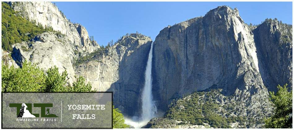
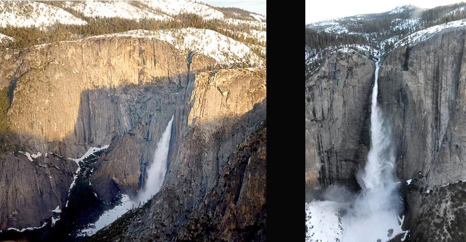
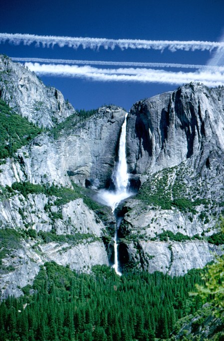
 YOSEMITE FALLS is located in Yosemite National Park which is located in the US state of California. It is one of the most spectacular waterfalls in the world. When it comes to height, the sign at the base of the falls says that its the highest waterfall in the United States and ranks 5th in the world, but this is debatable because the total height of Yosemite Falls is made up of three separate drops. The upper part of the falls drops 1,430 feet, the middle cascade drops 675 feet, and the lower part of the falls drops 320 feet, for a total of 2,425 feet. In the middle falls area, the water travels 800 feet before going over the next cascade that makes up the lower part of the falls. Having three separate drops brings other waterfalls into contention in the United States and around the world. There are three waterfalls in Hawaii, and two in the state of Washington that would top Yosemite Falls if you consider the height of an entire cascade. If you consider only the waterfalls with a clear drop, then Yosemite Falls would rank 2nd after Ribbon Falls, which drops a clear 1,612 feet. Ribbon Falls is located just a bit west of El Capitan in Yosemite National Park.
As you can see from the information above, getting a clear picture of a waterfall's height is a complex business to say the least, but when its all said and done, it is really all about the beauty of a waterfall rather than how it stacks up statistically, and if we are going to consider beauty as a key factor, then Yosemite Falls ranks very high indeed when compared to other waterfalls throughout the world.
Now that we have the issue of height out of the way, here are a couple of other statistics that you may find interesting. Yosemite Creek is entirely fed by melting snow and it drains an area of nearly 50 sq miles. The creek is what supplies the water source for Yosemite Falls, and at peak volume in late spring, a total of 2,400 gallons per second go over the lip of the upper fall.
 UPPER YOSEMITE FALLS TRAIL is one of the classic hikes in Yosemite, and is certainly one of the oldest trails in the park. John Conway began building the trail in 1873, and completed the section to the top of Yosemite Falls in 1877. The state tried to buy the trail in 1882 but Conway refused to sell. The state did not give up, and the battle for the ownership of the trail went in and out of the courts over a period of years. Conway finally decided to sell it in 1885 for a sum of $1,500.00 (in todays money the sale would be just a bit over $24,000.00). This is still an incredible bargain if you take into consideration all the hard work that must have gone into the building of this trail, from the lower meadows of Yosemite Valley to the top of Yosemite Falls.
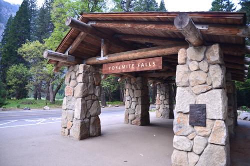
 Above you see a photo of "Yosemite Falls Shelter" that is one of the stopping points for the free Shuttle Bus that runs during the day. From here you can take an easy paved pathway to the bottom of Yosemite Falls, or, if you are more ambitious (and in decent physical condition) you can hike about a half mile to the Upper Yosemite Falls Trail-head (which is located just outside of Camp 4) and go for the adventure of hiking to the very top of Yosemite Falls located 2,559 feet above the Valley Floor.
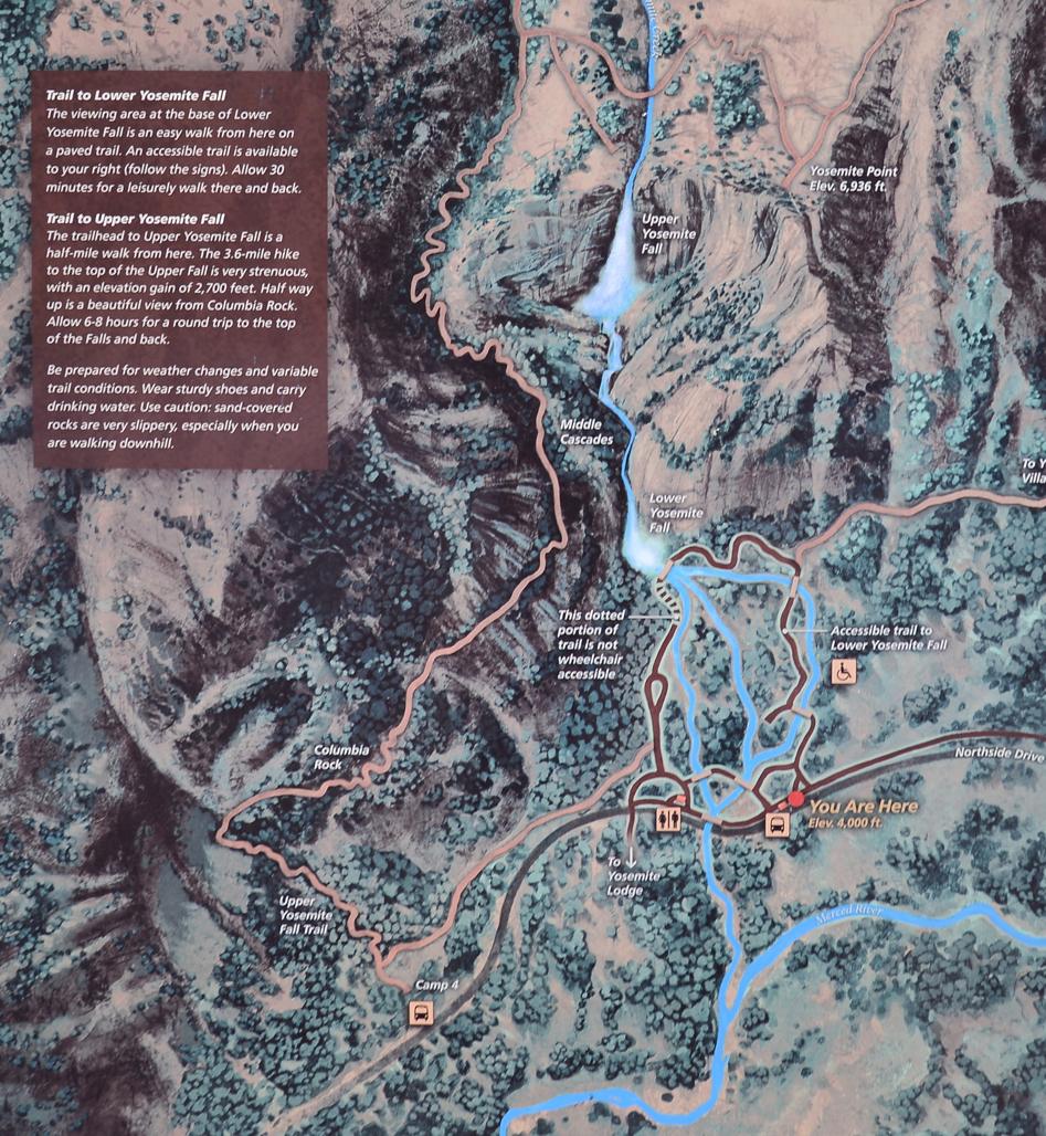 Below elevations in feet.
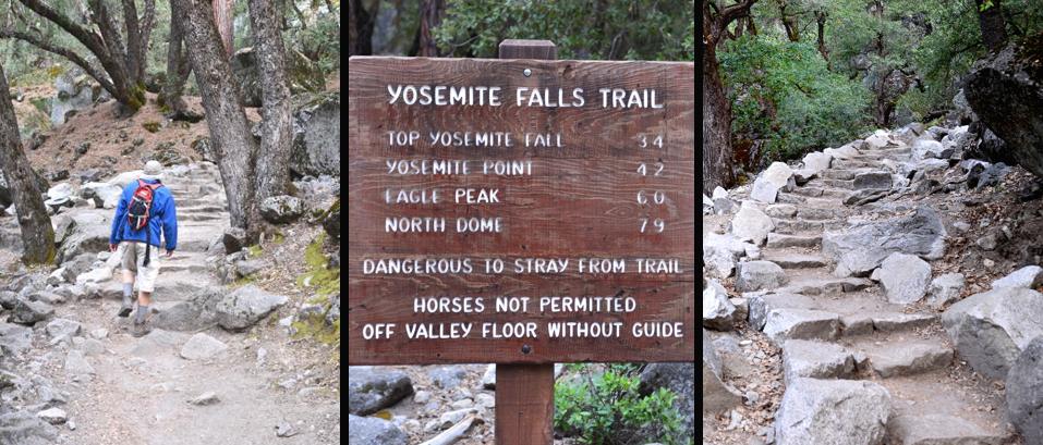
| Description | Elev | Miles | Elev Gain |
| Trail-head | 3,967 | 0 | 0 |
| Columbia Rock | 5,036 | 1.0 | 1,069 |
| Top of Falls | 6,526 | 3.4 | 2,559 |
| Yosemite Point | 6,936 | 4.2 | 2,969 |
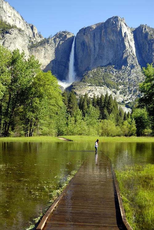 To the left you Above you see a young lady on the Sentinel Meadows Boardwalk which is partially under water. During times of heavy runoff (which usually occurs from mid to late spring) the meadows become flooded. This is a great time for photos and waterfall viewing in Yosemite National Park, and professional photographers and photo enthusiasts will take advantage of the boardwalk's key location to get many spectacular photos of the area. Is there any wonder that John Muir called Yosemite Valley the "Crown Jewel" of the Sierra Nevada?
Sentinel Meadow is named after Sentinel Dome which looms far above the meadow. The dome was named by the Whitney Geological Survey team in the 1800's. There is no doubt that the massive dome resembles a huge watchtower, and from its lofty summit you could imagine that one would keep perfect watch over Yosemite Valley below.
The Boardwalk is also part of the Sentinel Meadow and Cook's Meadow Loop, which is an easy 2.25 mile trail that travels along these two meadows. During the spring months, the meadows are lush and green (as shown in the photo above). After the water subsides a bit, the wildflowers in the meadow burst forth into a most colorful and spectacular bloom. The meadows are also a great place to view wildlife, if you are able to be there during the early morning or evening hours. Many Yosemite visitors spend the entire day strolling through the meadows and exploring the beauty that surrounds them. I have to say that there are few places in the world that offer so much grandeur and beauty. It all defies man's power of description.
 Camp 4 hosts the Trail-head to Upper Yosemite Falls, and is located on the North side of the Yosemite Valley. Camp 4 has been a hangout for rock climbers for several decades, and many of the early climbers went on to become world famous after initially honing their skills right here in Yosemite Valley's Camp 4. I used to pour over guidebooks and read stories about men such as Yvon Chouinard, Warren Harding, Tom Frost, and several others. I would marvel at the incredible feats these guys performed on the sheer rock-walls of Yosemite Valley.
 Camp 4 had been a sore spot for the National Park Service for years, and this all came to a head when the National Park proposed a new three story dormitory in Camp 4 after a flood in 1997. Climbers protested and Tom Frost led the charge. He got the American Alpine Club on board and sued the Park Service for the right to keep Camp 4 unchanged. The effort payed off, and on February 21, 2003, Camp 4 became a permanent listing on the "National Register of Historic Places" for its significance in the growth and development of rock climbing in Yosemite National Park.
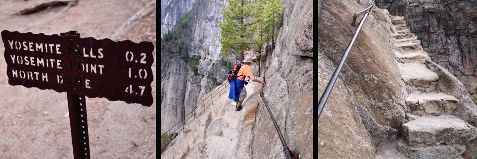
In the above photos you can see the Trail Marker listing the distances to key points and a hiker taking his first steps up the stone stairs that lead to the top of the Yosemite Falls. There are multitudes of these off camber irregular stone steps, and by the time you are done, you will have climbed the equivalent of 2+ empire state buildings.
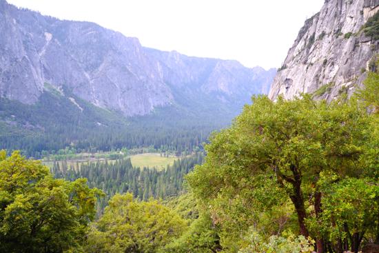
Above left Also above , you can see a photo of the valley below from Columbia Rock. Once you get to this point, you have traveled about a mile. It is a great place to take a break and capture a couple of photos. John Conway first blazed the trail to Columbia Rock, and was often hired by hotel owners to oversee the construction of nearly all the early tourist roads and trails in and around Yosemite Valley.
 After leaving Columbia Rock, the trail continues to rise upward but then levels out as it traverses towards the falls once again. It is a welcome relief from the many zig zags that led up to Columbia Rock. Also, the trees begin to gain stature and provide some much needed shade from the mid-day sun.
Make sure to bring at least a gallon of water for your hike, because this side of the valley gets lots of sun during most of the day, and you can become dehydrated very quickly if you run out of water and have no safe way of treating additional water sources that you may come across. For more on this subject, please visit our page on Water/Dehydration.
After about the first 1/4 mile of traversing towards the falls, the trail will turn downwards and you will lose a bit of elevation. I know that the trail builders often have no choice in matters like these, but going down when I know that my destination is upward always plays games with my mind. This is because I know that every step downhill will have to be made up for later. Oh well, I guess that's all part of the wilderness experience.
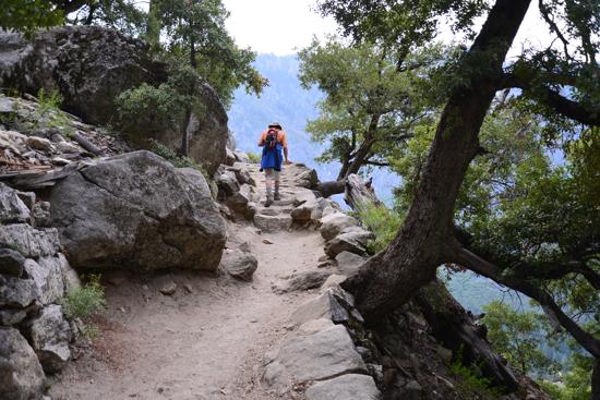
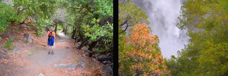
 After gaining back the elevation, the trail goes through a nice sandy and shady area before rounding a corner that opens up to your first full view of Upper Yosemite Falls. I have to say that its sights like the ones you see to the left that make hiking so fun.
 You are about halfway to the top of Yosemite Falls at this point, and this section of the trail is by far my favorite. The pathway here is pretty smooth, you have great views, nice shade, and if you decide to take a break, you could not ask for a better place. Many people decide to stop here and call it a day, but the mountaineering part of me always pushes me to the top.
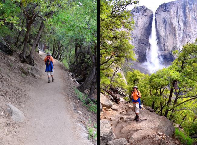
There is plenty more to come and there will be more than ample reward for the effort. As you can see in the photos below, the trail continues on a fairly level plane for a while, and there are places where you will be able to see beautiful cascading water though the gaps in the trees. During high runoff times (like we experienced during our mid-spring hike of 2013), a fine mist fills the air and provides a time of cool refreshment before making the final push to the top. The mist here is great on a hot day, but its nothing compared to the mist that you will experience if you decide to hike (what many would consider to be), the most popular trail in all the world. You can read all about this adventure by clicking on the following link - "Yosemite's Mist Trail"
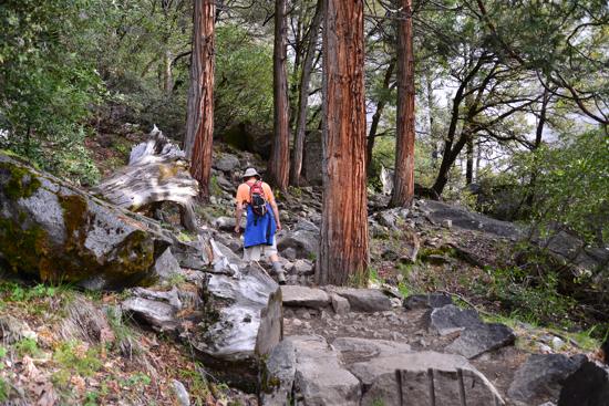 Once you complete the short (and most beautiful) section of the trail, you will find yourself back at work again gaining elevation on the stone steps of the Upper Yosemite Falls Trail, as shown in the image to the right. above. Now you will be surrounded by many large pine trees that really add to the beauty of the trail.
 You would never know it by looking at the cliffs from below that there is such variety of terrain along the trail. It looks like there is no way that you could hike to the top of Yosemite Falls (that are over 2,500 vertical feet above), when you are standing in the lower meadows of Yosemite Valley.
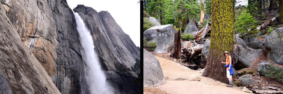
Below you see a photo of the upper falls, and it looks like you have a long way to go, but the last few hundred vertical feet go pretty quick. Additionally (in the lower right hand image), you can see a hiker who is very near the cut off point that leads to a little side trail. This side trail takes you to the Upper Yosemite Falls Lookout Point. When hiking in the drainage area that feeds Yosemite Falls, you will notice that you are walking on a very shallow layer of soil covering the hard granite substrate. Most of the terrain is made up of exposed granite, and without soil to promote groundwater retention, precipitation has the tendency to run off extremely fast. This effect is known as the "Yosemite Effect," and its one of the features that makes the waterfalls of Yosemite so spectacular.
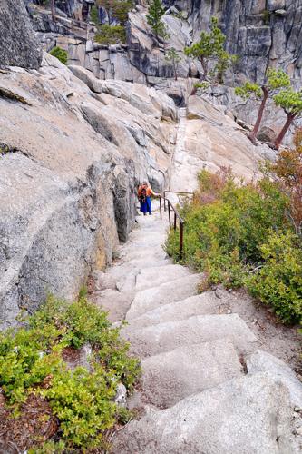 In the image to your left, In the image above, you can see a hiker descending the stone steps that lead to the Upper Yosemite Falls Lookout Point. From the trail marker (shown in the photo below), you will notice that the distance to the lookout point is 0.2 mile. This little side trail is mostly made up of stone steps that take you down to where Yosemite Falls plunges over the precipice into the valley below. It is a steep climb down to this special little viewing platform, but I believe that the extra energy spent making the round trip to the Yosemite Falls Viewpoint and back is well worth the effort.
Below you will see additional images of the stone steps as you continue down to the viewing platform. In one section the steps narrow to a point where you have only one handrail on the cliff side, and a steep drop off on the other.
Here you need to be very careful to hang on. If you are fearful of heights, you just may want to focus on the handrail and not look down (or just call it quits if you think its too much for you).
 Trail builders have done a great job in Yosemite, and I for one, am very appreciative of all the hard work that went into making all these wonderful areas accessible to the average hiker. Without these well engineered pathways, it would take monumental effort to negotiate the terrain that leads to these special places in the Sierra Nevada. Due to the incredibly steep nature of the terrain in Yosemite National Park (especially for trails leading up and out of the valley such as the Mist Trail and Yosemite Falls Trail), stone steps have been put in place to facilitate getting up and down the steep sections that you will encounter. These stairways take advantage of the natural layout of the surroundings and are about as good as it gets when it comes to trail building.
This is not to say that these stairways do not have their shortcomings. For instance, the rise on each step is not uniform (like you would find in your home or place of business), and the run of each step is not always level or equal in length and width by any stretch of the imagination. This means you will need to concentrate on proper foot placement when negotiating these hard granite steps. It is easy to stumble and hurt yourself, if you are not paying close attention to what you are doing, and to complicate matters, there is a lot of loose sand on the steps (unavoidable with so many hikers passing over them). You need to concentrate on balance and proper weight transfer as you climb. This becomes even more critical if you are descending, as most injuries occur on the way down and are caused by a lack of concentration, improper foot placement, going too fast, and/or, by hikers who are inconsiderate of others. The Upper Yosemite Falls Trail is rated "Very Strenuous," and participants need to pay careful attention to what they are doing so that they do not hurt themselves or others. In the photos below, you can see the platform and railing around the "Lookout Point" of Yosemite Falls. As mentioned above, over 2,400 gallons (enough water to supply all the needs of the average individual for about a month) go over the falls during peak flow each and every second. The sound of the fast moving water is thunderous.
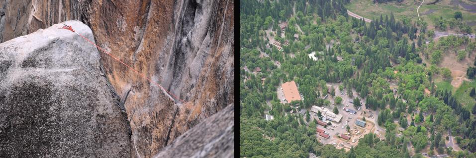
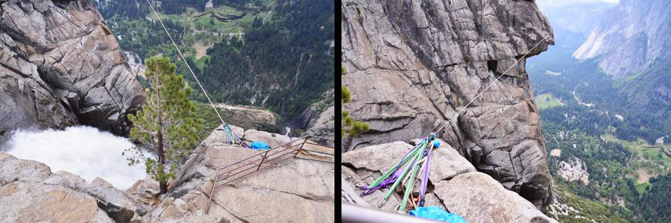 Note the rope that is strung over the falls. Climbers, no doubt, have put this rope into position (for what reason I'm not sure). Over the years I have learned that trusting setups that I stumble upon is not a good idea. You do not know how long the equipment has been in place. Anchors, ropes, slings, etc. deteriorate over time and sometimes its difficult to determine just how secure the main anchors actually are. However, I do have to confess that the thought did cross my mind that this setup could be used to get into a great position to take some cool photos of the water going over the falls, but alas, I did not have the necessary equipment to do the job, and the risk out weighed the benefit.
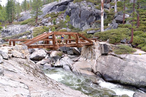 After climbing back up to the main trail, we proceeded to Yosemite Point. In the photo to the right above you see a wonderful footbridge going over Yosemite Creek. It is a super place to take some images of the beautiful landscapes that surround you.
After proceeding a short distance, you will find that the trail becomes a bit faint. It wasn't long after we left the bridge that we found ourselves on a little bunny trail that led to cross country travel. We did finally end up at our destination but it took a bit of rock scrambling to get there. Coming down we found it much easier to follow the trail, but on our way up, the trail was not so obvious.
Yosemite Creek (as seen rushing along below the bridge), is a 13.2-mile-long creek that starts at Grant Lakes and flows southwest before going over the falls. It then travels southeast to hook up with the Merced River (at Yosemite Lodge) just southwest of Yosemite Village. As stated above, its the waterway that drains the 50 square mile area that drains into it. During the later part of the summer months, the creek often goes dry (and obviously) this causes Yosemite Falls to go dry. This is why I think Yosemite is best in the spring when all the waterfalls are flowing at full force.
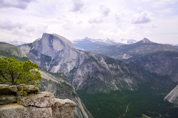 Yosemite Point has some of the best views in the Park. The panorama that unfolds before you is nothing short of awe inspiring and It is a great place to take beautiful photos of Half Dome as seen in the photo to the left. above.
 The hike to the top of Half Dome is another classic adventure in Yosemite. The final few hundred vertical feet on this escapade are completed on the infamous cable ladder. For much more on this subject see our web page on Half Dome.
Yosemite Point, at an elevation of 6,936 feet, not only gives you an incredible view of Half Dome, but also of the valley below. In the right hand lower image, you can see the structures of Yosemite Village through a telephoto lens. This super vantage point enables you to gaze out and see lots of peaks rising high above Half Dome in Yosemite National Park's high country.
Lost Arrow as seen in the below left hand image, was taken with a telephoto lens from a vantage point just below Yosemite Point. The first climb up Lost Arrow was an epic adventure for its time, and is still an incredible climb for modern day climbers. When looking from below, "The Arrow" is a detached pillar of granite rock just to the right of Yosemite Falls.
 The spire was originally summited by lassoing the summit from the main wall. Once the rope was in place, Ax Nelson prusiked the lassoed line to the peak followed by Jack Arnold. While Steve Roper called this "one of the greatest rope stunts ever pulled off in climbing history" many climbers did not recognize this "rope trick" as a true ascent. The recognized first ascent was later done as described below.
The "Lost Arrow Chimney Route" (which is listed as one of the classic climbs in North America), starts off with a rappel into "The Notch." From there, climbers go to work climbing the vertical walls of the spire. After reaching the summit, climbers do a "Tyrolean Traverse" across a fixed rope that spans the gap between the spire and the main wall. A Tyrolean traverse is where a climber attaches a short line from his climbing harness to the fixed rope, and then slides himself along the fixed line that crosses the open air space. This is done with the help of a carabiner or pulley that is attached to the main line that spans the gap. This climb was first completed by two legendary early Yosemite climbers named John Salathe and Ax Nelson. Aerial photos of Yosemite Falls in the pics below, show the drainage area above the falls during the winter months. In the lower right hand photo you can view the building up of an "Ice Cone." During the winter months, periods of sunshine start the falls back up again, and the trickle of water is transformed into pillars of ice by freezing temperatures at night. John Muir explained it this way "In winter the thin outer folds and whirling spray of the great Yosemite Fall are frozen while passing through the air freely exposed, and are deposited around the base of the fall in the form of a hollow, truncated cone, which sometimes attains a height of 400 feet."
 Deeper Insight - Yosemite Falls is truly one of the great natural wonders of the world, and millions of tourist come each year and marvel at the sight of this world famous waterfall.
 Have you ever thought of why so many people love waterfalls? They always attract crowds. It doesn't matter if you are taking a photo of Vernal Falls from the footbridge, gathered at the base of Bridalveil Fall, or viewing Yosemite Falls from a pullout along the side of the road, there always seems to be a crowd of people around you. I believe that people love waterfalls and fast moving water in general, because it demonstrate both power and beauty all at the same time. But beyond this, is the fact that all living creatures are drawn to water's life giving properties.
Could this be why the Bible uses water to describe so many spiritual principles?
POWER: His voice (God's) was like the roar of rushing waters, and the land was radiant with his glory. Ezekiel 43:2b
BEAUTY: He is like a tree planted by streams of water, which yields its fruit in season and whose leaf does not wither. Whatever he does prospers. Psalm 1:3
LIFE GIVING: Jesus answered, "Everyone who drinks this water will be thirsty again, but whoever drinks the water I give him will never thirst. Indeed, the water I give him will become in him a spring of water welling up to eternal life." John 4:13-14
Jesus is the living water that truly gives life, and the life that Jesus gives not only sustains us here on earth.....it sustains us for ETERNITY.
Whoever believes in me, as the Scripture has said, streams of living water will flow from within him." John 7:38
May God richly bless you as you continue to travel the trails of life,
Dave French

| Join the Adventure! Sign up here for Timberline Trails Monthly Newsletter |

Join us on Instagram
©2006-2026 TimberlineTrails. All Rights Reserved.
....