 Getting Started On White Mountain Peak - is an adventure all its own. From steep paved narrow canyon roads, to 16 miles of rough dirt road, you can be sure that it will be a trip you will never forget. Reaching the White Mountains and the Ancient Bristlecone Pine Forest from Big Pine, California is about a 45 minute drive from the little town of Big Pine. Once in town it is not far to where you will leave the main highway 395 and turn east onto highway 168. Once you are on highway 168 you will travel 13 miles to White Mountain Road. From there turn left (Forest Road) and continue another 7 miles to Schulman Grove (elevation 10,100 feet). Several beautiful turnouts are located on the White Mt. Road. My favorite is the Sierra View Overlook (see photo below). Schulman Grove and Patriarch Grove (along the way) are also worth visiting. Unlike in the Sierra Nevada, there is no need to get a permit to hike, climb, cycle, or ski to the top of White Mountain Peak.
While there are restrictions against camping within the boundaries of the Bristlecone Pine Forest, camping is allowed outside the previously mentioned area. Campfires are prohibited outside vehicles, but some sections on the mountain do allow campfires if you have a proper permit. A permit can be obtained from the US Forest Service or at a nearby Ranger Station. Lastly, to prevent tire track damage which remains on the landscape for years, vehicles are required to stay on established open roads only.
 To the left is a telephoto Above is a telephoto shot of the Palisade Crest in the Sierra Nevada. This is the highest continuous line up of peaks in the entire range. Here you see five peaks that exceed 14,000 feet all in a row. From left to right, are Mt Sill, Polemonium Peak, North Palisade, Starlight Peak, and finally Thunderbolt Peak.
A sixth peak, just out of view to the left, would be another 14,000 footer named Middle Palisade. The Palisade Glacier is also visible in this image and it is the largest glacier in the Sierra Nevada. Views like this are just another bonus while traveling on White Mountain.
Along the way to White Mountain Peak, you will pass a great scenic turnout where you can peer across the Owens Valley. From there you will be able to see a large section of the Sierra Nevada Range.
 As mentioned above, to get to your starting point for your hike up White Mountain Peak, you must turn off highway 168 just past Westgard Pass at around the 7,200 foot level and onto a dirt road. The road is fairly rough, but it can easily be done in a 2-wheel drive vehicle if you take your time. Roads like this do have a tendency to loosen up the underpinnings of your car or truck, and that can produce some very annoying rattles latter on (vehicle rattles drive me crazy). But if you take it easy, you can minimize these negative side
affects.
As mentioned above, to get to your starting point for your hike up White Mountain Peak, you must turn off highway 168 just past Westgard Pass at around the 7,200 foot level and onto a dirt road. The road is fairly rough, but it can easily be done in a 2-wheel drive vehicle if you take your time. Roads like this do have a tendency to loosen up the underpinnings of your car or truck, and that can produce some very annoying rattles latter on (vehicle rattles drive me crazy). But if you take it easy, you can minimize these negative side
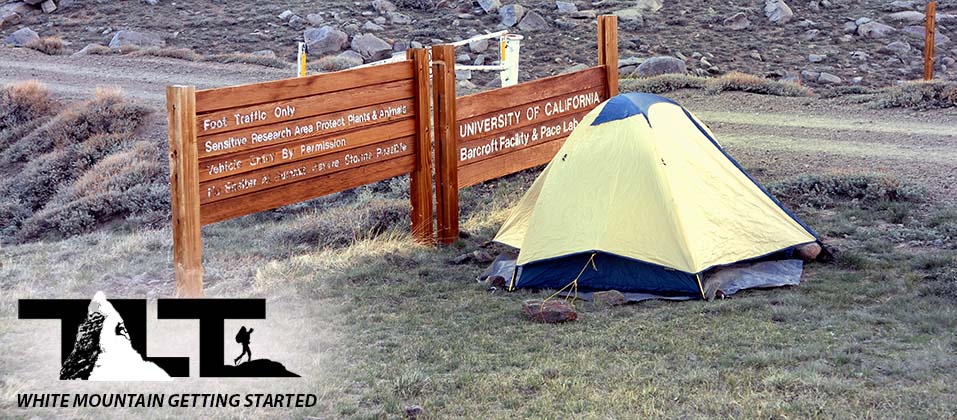
affects.The dirt section consists of a long 16 miles to the locked gate where you will begin your hike to the summit of White Mountain. The Barcroft Station (as you can see on the sign to the left) is 2 miles from the locked gate, but the 2 miles will need to be done on foot, since only Barcroft personnel are allowed to drive motorized vehicles to the research station. The last section of pavement is just above the Patriarch Grove at 11,500 feet, and it will give you a short break from the pounding dirt road. It is very likely the highest paved road in the whole state of California. You will also be passing the Patriarch Grove along the way, and a visit is well worth your time. There you will see the oldest living things on earth. The Bristlecone Pines. Silver Canyon Road, and Wyman Canyon Road, will give you access to the town of Bishop, California. These are dedicated 4-wheel drive roads. We took Silver Canyon Road up from Bishop on our first ascent of White Mountain Peak. The road was certainly rough, and some nice size puddles of water had accumulated after a recent rain. This only added to our 4-wheel drive adventure.
 In the image to the right, above, is the Schulman Grove Visitor Center. It is usually open from late May through the end of October. At the Visitor Center you will be able to make a quick study of the oldest living trees in the world. The cost is $3.00 per adult up to a maximum of $5.00 per vehicle; children under 18 are free. All the US Golden Passes are accepted, but if you do not have a pass, fees are collected at the Visitor Center during operating hours, or a self-service fee tube is located near the Visitor Center for after hours payment.
The center also has exhibits, a sales area, and a natural history section. Nearby, there are self-guided interpretive trails. All that you learned in the center will come to life if you take the time out to hike among these timeless treasures.
 In the left hand In the above image, you can see a few examples of these ancient living relics. Even though Bristlecone Pine Trees occur in five other western states, the oldest examples of the species are found in the ancient forests located in the White Mountains of California. Needless to say, these trees are tenacious of life,
and grow at elevations between 10,000 and 11,000 feet (which is timberline in the White Mountains).
In the left hand In the above image, you can see a few examples of these ancient living relics. Even though Bristlecone Pine Trees occur in five other western states, the oldest examples of the species are found in the ancient forests located in the White Mountains of California. Needless to say, these trees are tenacious of life,
and grow at elevations between 10,000 and 11,000 feet (which is timberline in the White Mountains).
Adding to the difficulty and rigors of the high altitude conditions of cold, wind, and lack of moisture, the oldest trees end up living in outcrops of dolomite. Dolomite is an alkaline calcareous substrate of low nutrient content. These conditions, on the other hand, are somewhat compensated for in that the dolomite rock has a higher moisture content than the surrounding sandstone does.
 Another benefit of dolomite is that it can reflect more sunlight than other rocks, and this contributes to a cooler and moister root zone. On your right, is an example of a gnarled, wind polished Bristlecone Pine. The wood is beautifully sculptured by the harsh environment of the White Mountains, and
even after dying, the structure will continue to be polished by the wind driven ice and sand. In the end, the remains will often take on the appearance of a ghostly apparition during a moon lite night.
Another benefit of dolomite is that it can reflect more sunlight than other rocks, and this contributes to a cooler and moister root zone. On your right, is an example of a gnarled, wind polished Bristlecone Pine. The wood is beautifully sculptured by the harsh environment of the White Mountains, and
even after dying, the structure will continue to be polished by the wind driven ice and sand. In the end, the remains will often take on the appearance of a ghostly apparition during a moon lite night.Bristlecone pine needles can live from twenty to thirty years old. This reduces the amount of energy that is normally required for needle production each year by traditional pine trees, and the older needles also provide a stable photosynthetic environment to sustain life during years of severe stress. Another benefit to long lived needles is that the trees do not produce a lot of debris on the ground. This greatly reduces the risk of spreading fire after a lightning strike on a neighboring tree. Another key to longevity for the Bristlecone Pine is that invasion from bacteria, fungus and insects are unknown to the Bristlecone. This is because the trees have a dense, highly resinous wood that is impervious to the aforementioned problems. The White Mountains also have the driest air in the world and this helps keep the trees from rotting.
These ancient trees grow very slowly, and the short 45 day growing season along with inhospitable conditions only add to the slow growth. It will take upwards of a hundred years to add just an inch of girth to these very special trees. This along with many other reasons is why care must be taken when visiting the groves. Stay on designated paths and avoid human contact with the trees. Climbing and or walking on the fragile root system can greatly reduce the life of these ancient trees.
Bristlecones can reach a height of 60 feet, but most never reach that lofty a stature. The Patriarch Tree which is located in the, (well you guessed it), the Patriarch Grove, is 36' 8" in girth. This makes it the most robust of the Bristlecones. This particular tree is relatively young at the age of 1,500 years, but it is older than the average Bristlecone Pine which clocks out at about 1,000 years. Very few trees have reached the 4,000 year mark, but the "Pine Alpha" is one of the exceptions. In 1957 it was renamed "Methuselah" after the oldest human ever recorded in the Bible. Methuselah (the tree) was found to be 4,723 years old and has the distinction of being the oldest known living thing on earth. The location is being held secret so that visitors (sad to say) will not be tempted to vandalize it.
 To the left is Above is an example of one of the self-guided interpretive trails. Note the nice concrete stairway that has been put into place to ease your effort as you climb alongside the oldest living things on earth.
There is also a second grove that is a 12-mile drive north of Schulman Grove. You will pass this grove on the way to the trailhead of White Mountain. The grove is near tree line and it is the home of the world's largest Bristlecone Pine, the Patriarch Tree. The grove is named Patriarch Grove after this giant Bristlecone Pine.
On one of our trips up White Mountain my youngest son got altitude sick while sleeping at the trailhead of White Mountain Peak. So we had to abandon the climb. But rather than count it all loss, we dropped down a bit, and spent the day exploring the Patriarch Grove. We found that it was time well spent. Always plan to have your camera along. You will not want to miss getting some photos of the many fine specimens you will come across.
The Schulman Grove is named after Edmund Schulman who began his career of tree dating (dendrochronology) in 1932. At that time, he was an assistant to A.E. Douglass in the "Tree-Ring Laboratory of Research" located at the University of Arizona. Schulman had a background in astronomy, and he used his astronomy background to relate cosmic events to the science of tree-ring dating.
In 1958 Schulman and his colleagues prepared an article for National Geographic and it later brought worldwide attention to the White Mountains. But unfortunately, Edmund Schulman never lived to see the article published. He was struck down by a heart attack in 1958 at the young age of 49 just before the article was published. But happily in that same year, the U.S. Forest Service did establish the 28,000 acre Ancient Bristlecone Pine Forest, and named one of the sections Schulman Memorial Grove, to honor his contribution to the world.
 In the image to the right, above, snaking off into the distance, you will see the dirt approach road. It leads to the traditional locked gate starting point on White Mountain. Scenes like this give you a sense of isolation as you travel along the windswept slopes of White Mountain. When this area is under snow, it is a great place to cross country ski.
Make sure you have plenty of fuel and that your vehicle is in good working order before leaving the main highway. Getting stuck in this remote area would certainly take all the fun out of your trip. I cannot imagine what the cost of getting a tow truck way out here would be.
Even though you will get cell phone reception on the top of White Mountain Peak, (and in other areas that have a clear shot down to the Owens Valley), nearly all the dirt road areas shown here are very isolated, and you will not have the ability to call out.
 As you continue on your 16 mile journey on the dirt road, White Mountain Peak will finally come into view (as seen to the left). above). You still have a ways to go from this point, but you will be there soon enough. The interesting terrain helps the time go by and there are many photo opportunities.
Traveling on this road in the late afternoon can be very spectacular in its own way. As the sun descends, it casts beautiful long shadows and makes the landscape come to life.
 The White Mountains have a landscape all their own and the sub-alpine zone is very different from other mountainous regions around the world. The climate of sub alpine ecosystems is dominated by very long winters and short growing seasons of 6–9 weeks. Temperatures are cool even during the growing season and frost can occur 12 months of the year. Add to this very dry conditions that are typical in the White Mountains, and you have a very severe environment for life. Nevertheless, I believe you will find the whole experience of being in the White Mountains very special.

 Here I have included a couple of photos (above and to the right) (above) to give you an idea of the variety of terrain
you will come across while traveling on White Mountain. These photos were taken in the latter part of June 2008. From complete barrenness(upper right image) to the inviting light green grassy slopes, White Mountain will delight your senses.
Here I have included a couple of photos (above and to the right) (above) to give you an idea of the variety of terrain
you will come across while traveling on White Mountain. These photos were taken in the latter part of June 2008. From complete barrenness(upper right image) to the inviting light green grassy slopes, White Mountain will delight your senses.The light green grass combined with the snow and isolated stone structure in the photo to the right, reminded us of the Scottish Highlands. As I have so often remarked, no photo can compare to what the human eye is capable of taking in.
Adding to the beauty, is the quiet lonely environment of the White Mountains. It gives one the opportunity to reflect on the more subtle things in life. The clear dry air makes it so you can see into the distance for more than a hundred miles, and the incredible stillness makes it so you could almost hear a pin drop.
 Well, were finally there, and if you look closely at the photo to the left, you will see the locked gate on the far left side. This is the starting point for a traditional hike up White Mountain Peak. Also note the light brown structure in the image. This is the last public restroom you will come across. It is in good shape and it is well stocked with toilet paper.
From the vantage point of the parking lot, you will be able to see a spectacular view of the Sierra Nevada Range across the Owens Valley, and if you walk out a bit on the nearly flat terrain, you will get an even better view. As mentioned above, you will get a tremendous view of the highest continuous ridge in the Sierra Nevada. The peaks making up this spectacular ridge are know as The Palisades.
This is as far as you go with your vehicle. From here on you will need to be on foot or bicycle. Hiking is much easier than cycling, when going up, but I will take the bike any day for coming down!
 The trailhead area has plenty of parking, and when we arrived early evening on June 21st of 2008, we were nearly all alone (there was one
lone camper who left shortly after we arrived).
The trailhead area has plenty of parking, and when we arrived early evening on June 21st of 2008, we were nearly all alone (there was one
lone camper who left shortly after we arrived).This was not the case on our July 4th 2009 hike up White Mountain. When we arrived at around 5AM the next morning (after sleeping at about the 10,000 foot level further down the road), we saw many campers sleeping in tents and in the backs of their vehicles near the locked gate.
Camping at the trailhead is no problem, and there are no restrictions (other than fires). But you will need to be somewhat acclimated, because you are at 11,670 feet above sea level. This can lead to a nice headache or worse if you are not accustomed to the altitude. This is why we decided to camp a bit lower (at 10,000 feet) to help us out a bit to prevent altitude sickness (which is one of the more difficult factors when climbing White Mountain.
 To the left Above is a view of the parking area and the locked gate from a different vantage point. As you can see, the trail is really not a trail, but a fairly wide dirt road that is very similar to the one you just traveled on. The first two miles lead to the
Barcroft Research Station, and the road is well maintained to that point. From there on it gets much rougher and narrower.
To the left Above is a view of the parking area and the locked gate from a different vantage point. As you can see, the trail is really not a trail, but a fairly wide dirt road that is very similar to the one you just traveled on. The first two miles lead to the
Barcroft Research Station, and the road is well maintained to that point. From there on it gets much rougher and narrower.The final slopes to the summit get even tighter and much steeper. You would need a pretty good 4-wheel drive vehicle to get to the top of White Mountain via this method. The road as mentioned before, is for employees only, so the rest of us will have to travel on foot or bicycle. I would say that 99% of the people I have seen travel on foot.
I cycled to about the halfway point on one of our White Mountain outings, and I have to say that White Mountain is a killer climb on a bicycle. This is no doubt due to the fact that the air is much thinner than what most cyclists experience, and the road is pretty steep. Also, there are lots of rocks to avoid and this makes travel even more difficult. The evening before setting out for the peak, I took my mountain bike up the road (that you see in the photo above) for a little experiment to see just how tough it was going to be in the morning. But while coming down I hit, what I thought, was a no big deal of a rock. However, it was just enough to pinch the tube in my front tire. It totally flatten it, and I didn't have a spare tube. So I ended up using my friend's mountain bike the next day while he and my oldest son and his friend hiked to the top of the mountain on foot. In the meantime, I spent the day playing around with the bike and went (as mentioned above) to about the halfway point. Later on, I was told that you need to keep your mountain bike tires at a high pressure in order to avoid such a mishap. Carrying along a spare tube would also be an obvious precaution. Sometimes you end up thinking about these things after the fact.
 To the right Above is a photo of a sunset near the locked gate starting point on White Mountain. The air is extremely dry and the location is far away from major areas of civilization. This keeps the air very crisp and clean, and makes for
beautiful blue skies and vibrant colors.
To the right Above is a photo of a sunset near the locked gate starting point on White Mountain. The air is extremely dry and the location is far away from major areas of civilization. This keeps the air very crisp and clean, and makes for
beautiful blue skies and vibrant colors.The nights are special too. Sleeping out under the stars is a great experience. On White Mountain (if you have a moonless night) you will be able to see a blanket of stars and a clear view of the edge of our Milky Way Galaxy. If you have a telescope, White Mountain would be a great place for it. This is because of the extemely dry air in this region. Very little to get in the way of a clear view of the heavens above.
With fewer and fewer places on earth where you can go and get away from it all, White Mountain begins to take on an even more important place in the hearts of those who take the time out to visit its barren slopes.
 During the winter of
2004-2005, the White Mountains, along with the Sierra Nevada and other surrounding areas received the heaviest snowfall in a 100 years. Death Valley the following spring had a flower bloom that was second to none.
During the winter of
2004-2005, the White Mountains, along with the Sierra Nevada and other surrounding areas received the heaviest snowfall in a 100 years. Death Valley the following spring had a flower bloom that was second to none.Above, you see the White Mountains reflected in a rarely formed lake of still water located in the Owens Valley. Due to the fact that the Owens valley is located between the White Mountains and Mt Whitney (both over 14,000 feet in elevation) it makes the Owens Valley (being over 10,000 feet below) one of the deepest valleys in the United States.
My son Sean took this photo during that special winter of 2005. After traveling the globe, world renowned photographer Galen Rowell, considered the Owens Valley one of the most beautiful places on earth. SUMMARY:
- White Mountain can be easily reached from the town of Big Pine or Bishop located along California Highway 395. See above for directions.
- Make sure your vehicle is in good working order, and that it has plenty of fuel. The final approach is a remote dirt road, and breaking down could be both costly and very inconvenient to say the least. In winter time, a vehicle malfunction could become downright dangerous.
- Have proper clothing, and plenty of water along. White Mountain temperatures are capable of going well below freezing, and water sources are very unreliable. White Mountain is also known for its cold and often times ferocious winds, especially in winter months. So make sure you carry along a good wind breaker. This will enable your insulating layer of clothing to perform as designed.
- White Mountain's air is the driest on earth. So make sure to drink often. Proper hydration will help you alleviate cramping and other ill effects, such as high altitude sickness.
- Try and reserve time on your trip to explore the Bristlecone Pine Forests. The Schulman and Patriarch Groves are unique in all the world and are home to the oldest living things on earth.
- White Mountain is the easiest fourteen thousand foot peak in California. The challenge of gaining the summit is not the technical difficulty, but the altitude. Travelers coming from lower elevations will gain many thousands of vertical feet in their vehicle and will quickly reach the traditional 11,670 foot starting point for a hike or climb to the summit. This is a ticket for altitude sickness. If you find yourself subject to this ailment, then it would be best to spend a night or two at a lower elevation to acclimate. This will give you a better chance for success and lessen the possibility of annoying headaches, nausea, and/or something worse. I usually require one night at nine or ten thousand feet before going on to the summit of White Mountain.
- Always carry a headlamp on all mountain adventures. The distance from the locked gate to the summit and back is 14 miles. Even though White Mountain is the least difficult of California's 14ers, it still will require stamina and endurance for the round trip. People who start out late in the day, or find themselves resting and sitting a lot, may get caught on the mountain after sunset. A headlamp will enable one to continue in the dark with relative safety due to the easier conditions of hiking on a fire road during the summer months. But without a headlamp, you may find yourself dangerously stumbling about in the dark trying to negotiate your path.
- It is always best to start out early in the mountains. We try and get started before 6AM or earlier on White Mountain. This way we can get back down to the trailhead by early afternoon and drive off the mountain before nightfall. An early start also enables you to avoid the heat of the high altitude sun on the lower sections of the trail.
- If cycling is your thing, then make sure to pump your tires up to the highest pressure that is safely allowed. The dirt road to the top is filled with many unforgiving rocks, and they can easily slash tires and/or pinch tubes. You will also need to be in top physical condition. Cycling to the top of White Mountain is brutal work, and it is far more difficult to cycle to the top than to hike there. Thin air and steep slopes will challenge even the best of cyclists. So if you are not in fantastic shape, plan on hiking to the summit (this is not to say that you will not need to be in decent condition to make the summit on foot). Otherwise, you will end up pushing your bike much of the time, and this will defeat the whole purpose of even bringing it along. Once on top, the advantage turns from the hiker to the cyclist, big time......But you will now need to be even more careful. Increased speed on the way down will escalate the danger of hitting a sharp or large rock. This could put an instant end to an otherwise quick descent.
- As always, practice good mountain sense. Never travel alone, and let loved ones know what route you plan to take and when you plan on returning. Many novices will attempt the hike up White Mountain and some will bite off more than they can chew. Mt Whitney also has a trail to the top, but every year (according to the Inyo National Forest Site) visitors become sick, injured; and sometimes die. Almost all illnesses, injuries and fatalities occur on Mt. Whitney’s "easiest" routes (including the Mt. Whitney Trail as previously mentioned).
The White Mountains have much to offer. Hopefully our getting started page has not only tuned you in on how to plan for your hike or climb up White Mountain Peak, but has also alerted you to the other activities that you can enjoy along the way. Over the years I have found that half the fun (if not more) of hiking, backpacking, mountaineering, and climbing is getting there. So always try and reserve a little time for side trips. They can add much to any adventure you go on. For more adventure in the White Mountains click on the above menu and select the White Mountain option for more adventure on this beautiful desert peak.
Email Sign Up

| Join the Adventure! Sign up here for Timberline Trails Monthly Newsletter |

Join us on Instagram
©2006-2026 TimberlineTrails. All Rights Reserved.
....