 Mount Rainier is located in the US State of Washington, and is certainly one of the most beautiful and majestic peaks in the entire United States. Rising 14,411 feet above Puget Sound, it stands tall above its beautiful surroundings and claims the title of the highest volcano in the contiguous United States. Mt Rainier was recognized early on as a place to be preserved, and on March 2, 1899, it became a National Park.
Mt Rainier has become an irresistible attraction for climbers from all over the world. Steep glacial ice, crevasses, serious elevation gains, and much much more have challenged climbers of all abilities over the many years since the first documented climb on August 17, 1870, by General Hazard Stevens and Philemon Beecher Van Trump. Due to its uniqueness, grandeur, and sheer height, Mt Rainier reigns as King when it comes to Cascade volcanoes. I remember my first attempt on Mt Rainier many years ago, where we started off with a beautiful sunny day only to be pinned down at Camp Muir that same day. The next day the storm continued and we decided to call it a day and make a quick descent. That experience left its mark and we didn't return for a couple of decades where we came back better prepared and were able to make the peak under much better conditions. But no matter how well you prepare for a mountain like Mt Rainier, weather is often the wild card that you just can't fully prepare for!
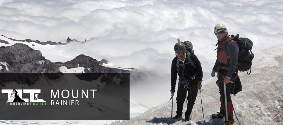
 To the left you see a climber just above the cloud level at 10,000 ft with Mt Adams in the background. Mount Rainier has a topographic prominence of 13,211 feet, which is greater than that of K2 (13,189 feet).
Mt Rainier ranks 21st in the world on this scale and on clear days it dominates the southeastern horizon in most of the Seattle-Tacoma metropolitan area. The mountain can be seen from as far away as Portland, Oregon, and Victoria, British Columbia.
As far as weather is concerned (as mentioned above), Mt Rainier seems to make its own weather. This is because the mountain stands in the path of prevailing moisture laden marine winds. Its southern slopes get some world breaking snow fall, and Paradise Inn (a three story lodge) is frequently buried to the tops of its chimneys in snow. High altitude, whiteouts, fierce winds, extreme cold, steep glacial ice and huge crevasses will challenge even the best of mountaineer's. This is what makes Mt Rainier such a great training ground for future world class mountaineer's.
 Due to the heavy snowfall on the slopes of Mt Rainier (mentioned above), the mountain sports 26 major glaciers covering more than 35 square miles, and claims the title of the largest single-mountain glacier system in the United States outside of Alaska.
The Emmons Glacier, which is nearly five square miles in area, is the largest glacier in the nation outside Alaska. The Carbon, Tahoma, Winthrop, and Ingraham are second in line, and take up anywhere from four square miles to 1.3 square miles each.
In the above photo, you see a couple of climbers on the Muir Snowfield with the Nisqually Glacier in the background. Because of the sheer number of glaciers on Rainier, it is not possible to reach the summit without crossing one of its many glaciers. Climbers gain 2,800 vertical feet on the snowfield from Pebble Creek to Camp Muir. Many years ago the National Park Service put up at the beginning of the Muir Snowfield that read as follows: "STOP! The Climb to Muir is long and hard. Storms come fast with little warning. Some have died on the slopes ahead. Turn back here if alone or lack proper equipment. If weather turns bad while en route, descend immediately." The sign is no longer there, but the warning is just as valid today as it was then. I remember the first time we attempted Mt Rainier in the late 1970's when signing up for a permit we were taken aside by a climbing ranger and quizzed about our previous experience and our knowledge of our gear. That is no longer the case today, so you need to make sure you are up the challenge before you even consider an ascent of Mt Rainier.
 Climbing on Mount Rainier is difficult, involving traversing the largest glaciers in the U.S. south of Alaska. Most climbers require two to three days to reach the summit. Climbing teams demand experience in glacier travel, self-rescue, and wilderness travel. Ninety percent of climbers use the Camp Muir approach on the southeast side, and most of the rest ascend Emmons Glacier via Camp Schurman on the northeast. About half of the attempts on Mt Rainier are successful. Weather and conditioning are the most common reasons why climbers fail to reach the summit.
About three Mountaineering deaths each year occur due to rock and ice fall, avalanche, falls, and hypothermia associated with severe weather. The worst mountaineering accident on Mount Rainier occurred in 1981, when eleven people lost their lives in an ice fall on the Ingraham Glacier. This was the largest number of fatalities on Mount Rainier in a single incident since 32 people were killed in a 1946 plane crash on the South Tahoma Glacier.
A few days before our climb on Mt Rainier, a man lost his life near the summit, due to the cold and extremely high winds. And then, three weeks later, after we returned from our climb, four climbers fell on the Emmons Glacier, and went into a 35 foot crevasse where one of the climbers lost his life in the fall.
To the left, you see a climber practicing on a steep snow and ice slope just outside the Camp Muir area. Mt Rainier is certainly a great place to practice your snow and ice skills. But be warned, Mt Rainier, as stated above, can be deadly and novice climbers should not attempt to climb Mt Rainier without proper training and guidance.
Even expert climbers are not immune to objective dangers when it comes to Mountaineering. Rockfall, ice fall, crevasses, avalanches, blizzards, Altitude Sickness, just to mention a few, are ever present and can never be taken lightly. But most deaths and accidents are caused by improper or too little training, bad decisions, poor planning, inadequate conditioning, and so forth. This is why you need to first assess your abilities, but must also carefully select the people you climb with. Your very life may depend on your teammates.
 Mt Rainier is a technical climb, and proper skills are required. Proficiency with an ice ax, crampons, roped glacier travel, crevasse rescue, and other skills are a must.
Many mistakes are made when beginners take on any sport, but usually mistakes do not cost one his life in most sports. But mountaineering is different in that the mountain does not care about your inexperience, and will not give you any special considerations when a mistake is made. Thus, climbers every year loose their lives on Mt Rainier.
Just above, you see a climber crossing over a good sized crevasse on a ladder on the Ingraham Glacier at about the 11,600 ft level. An un-roped fall off the ladder could very likely be fatal.
All glacier travel should be done roped. This is why solo climbs on Rainier are extremely dangerous. But if a fall takes place your teammates need to not only have the proper equipment in tow, but be adequately trained in crevasse rescue. Ascender's work best when climbing out of a crevasse.
 Reaching the summit requires a vertical elevation gain of more than 9,000 feet over a distance of eight or more miles. Climbers must be in excellent physical condition and well prepared.
I cannot emphasize enough the importance of conditioning. It can make the difference between success and failure, and even more importantly, it makes a difference when it comes to your safety. Overly tired climbers are far more likely to make mistakes. For more on this subject, please visit our page on Conditioning.
Also, Weather, snow, and route conditions can change rapidly. Severe winter-like storms on the mountain are not uncommon, even during the summer months. During the aftermath of these storms, one must pay close attention to avalanche conditions and other hazards such as hidden crevasses. Recognizing slope angles is a critical part of assessing avalanche danger. On Mt Shasta, we learned that 30 to 45 degree slopes are particularly prone to avalanche under just the right conditions.
 Mt Rainier is a place of wonder and beauty. It is a world of alpine ice and rock, and holds a beauty all it's own. I have climbed many peaks in the Western United States, and I have to say that Rainier ranks very high on my list when it comes to mountain adventure.
There are pinnacles of ice, jumbled ice blocks the size of houses, deep crevasses, pristine forests, and so much more. The base of Mount Rainier spreads over an area of 100 square miles. The scenic area around Rainier covers more than 230,000 acres.
While it is great to enjoy the views of the ice-covered summit of Mt Rainier, the best way to enjoy the mountain is to climb it. But inexperienced climbers or novices should not attempt Mt Rainier. It is certainly no place for beginners. But even for non-climbers, the towering giants of the old growth forests and colorful wildflower meadows with views of the peak are just as rewarding in their own ways.
In this section of Timberline Trails, we would like to take you on an adventure to the top of Mt Rainier using the Ingraham Glacier Direct Route/Disappointment Cleaver. These are the most popular routes on the mountain, and are considered true Rainier classics and offer stupendous views of Gibraltar Rock and Little Tahoma.
The elevation gain is substantial, however, being 9,000 vertical feet from Paradise. More than 12,000 climbers a year attempt to climb Mt Rainier with a success rate of just under 50%. I found Mt Rainier to be one of the greatest adventures of my life. So if you are looking for a challenging mountaineering experience and you have the necessary skills, Mt Rainier will leave little room for disappointment.
So whether you are a climber or not, we hope that you will enjoy exploring this section of Timberline Trails, and that you will be inspired by this beautiful mountain that makes up part of God's wondrous creation.
Dave French
Email Sign Up

| Join the Adventure! Sign up here for Timberline Trails Monthly Newsletter |

Join us on Instagram
©2006-2026 TimberlineTrails. All Rights Reserved.
....