 Getting Started on Climbing Mt Shasta - is a matter of getting there first. The mountain is located in the Northern portion of the US State of California. Fortunately, getting to Mt Shasta is fairly straight forward. Super highway Interstate 5 gets you there no matter if you are coming from the North or the South. If you are coming from the East or West, it is still best to traverse over and hit the Interstate 5. Then proceed in the appropriate direction.
 Mount Shasta City exit is where you want to leave the highway. You then travel Northeast through the town to Everitt Memorial Highway which leads to Bunny Flat, and other trailheads. For our particular outing on May 16-17, 2009 our starting destination was Bunny Flat at 6,950 feet (3,326 feet above the little town of Shasta).
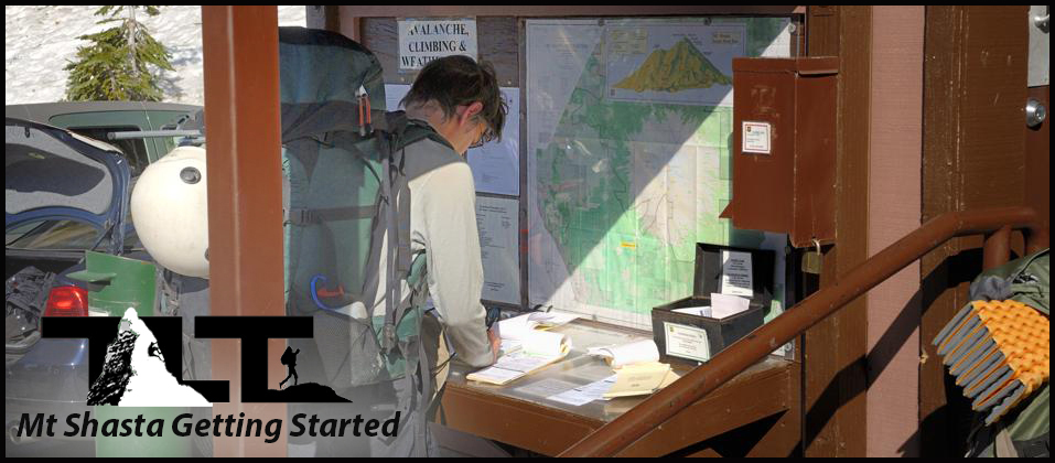
Once at Bunny Flat, the next order of business is registering for the climb and paying your fees. Summit Passes are required to climb or ski above 10,000 ft in the Mount Shasta Wilderness. A 3-day summit pass is $25.00 per person and is available as a self issue permit at open trail heads and outside the Mt. Shasta city Ranger Station 24 hours a day. It is also available at a variety of outdoor stores in Northern California. Annual Passes which are good from Jan 1 to Dec 31st are $30 and currently only available at the Mount Shasta Ranger Station (Phone# 530-926-4511) and McCloud Ranger Station (Phone# 530-964-2184) from 8:00 am to 4:30 pm Mon-Fri, and at "The Fifth Season" during business hours. In the above header photo you see my son Sean filling out his registration papers at the Bunny Flat station. Each person is required to register and pay an individual fee as mentioned above.
 Bunny Flat parking area can certainly be crowded, as you can see in the image
to the right.
above.
We tried to miss the Memorial Day crowds by climbing the mountain a week earlier, but it seems as though many others had the same idea.
Bunny Flat parking area can certainly be crowded, as you can see in the image
to the right.
above.
We tried to miss the Memorial Day crowds by climbing the mountain a week earlier, but it seems as though many others had the same idea.But not all people were setting out to climb the mountain, because there were several folks that came there to snowboard, ski, or just plain enjoy the fresh new snow. Nevertheless, the crowded area forced us to park well down the road in order to get a place to put our vehicle for the weekend. Under the above conditions, we found ourselves in the snow as soon as we left the pavement, and rarely saw any soil until we returned to this area a day later.
On a positive note, the snow cover gave us direct access to our midway camping spot at Lake Helen. It made it so we did not have to wind around on a trail that only becomes useful later on in the year. Trails provide quick access to destinations, while cross country travel through rocks, branches, and other such obstacles requires extra time and energy. On our trip we had good snow cover and all the above mentioned problems of cross country travel were no problem at all. The ample snow cover provided a smooth path over them.
 The structure at Bunny Flat as shown in the
left hand
above
image also houses a couple of rest rooms. A barrel of toilet bags is also available here. All back country travelers are required to pack out their solid waste these days. Multitudes of visitors on the mountain have forced this mandate. When you see the number of people visiting the mountain terrain, it becomes obvious that human waste needs to be controlled so that future visitors will be able to enjoy a pristine environment. The station also provides a place to discard your bags after you return from the mountain.
The structure at Bunny Flat as shown in the
left hand
above
image also houses a couple of rest rooms. A barrel of toilet bags is also available here. All back country travelers are required to pack out their solid waste these days. Multitudes of visitors on the mountain have forced this mandate. When you see the number of people visiting the mountain terrain, it becomes obvious that human waste needs to be controlled so that future visitors will be able to enjoy a pristine environment. The station also provides a place to discard your bags after you return from the mountain.There is a total of nine hiking trails on Mount Shasta. Two of the nine trails begin at Bunny Flat, which is located 3 miles from the Everitt Memorial Highways end. The two trails are the Horse Camp Trail and the Green Butte Ridge Trail. We went cross country in the snow to get to Horse Camp Hut, but in later season the Horse Camp Trail is the way to go. The Green Butte Ridge Trail is a beautiful trail that will give you very scenic views of Mt Shasta. Everitt Memorial Highway is the only paved road that gives access to Mt Shasta. Bunny Flat is the high point along the road, and if you are just out to get some great photos (with just a bit of a hike), you can get some great shots of Mt Shasta. The below left hand photo was taken after hiking less than two miles from Bunny Flat and gives you an idea of how beautiful the scenery is on Mt Shasta.
 The photo to the above right was taken near the trailhead, and the signs are a final reminder of the requirements for traveling above 10,000 feet on Mt Shasta. Be sure to carry you registration and Summit Pass with you at all times. US Forest Service Rangers are ever present on the mountain, and you will very likely be asked to present your paperwork. We did. So keep it handy for inspection.
All the above being said, it is best to also check out weather conditions and avalanche dangers before even setting out on your adventure. For current weather conditions at 12,366 feet on the mountain, click here, and for Avalanche Conditions click here.
For real time web cam of Mt Shasta from below, click here.
Good planning always pays off, and the more information you have available to you when it comes to planning your outing on Mt Shasta the better.
- Mt Shasta is located in the northern portion of the US State of California. It is most easily reached by making use of Interstate 5, and using the Mt Shasta City off ramp. On the northeast portion of town, you pick up the Everitt Memorial Highway that takes you to Bunny Flat trail head and other starting points on the mountain.
- Be sure to check weather and avalanche conditions before setting out on your trip. Even though mountain weather can change rapidly, why start out when the forecast is poor? Mountain travel is hard enough, so why add to it if weather and/or avalanche conditions are not in your favor.
- The best time to climb Shasta is from late May through June. During this period (for most years) you will have good snow cover for easier travel. Mt Shasta can certainly be climbed in the later summer months, but dry scree and rock filled slopes make upward progress grueling at best, and rockfall becomes a serious problem. Many people have been injured and some killed due to rockfall on the mountain.
- Winter climbing on Mt Shasta is a very serious undertaking due to harsh weather and extreme cold. Those who engage the mountain during winter season need to be well prepared and trained in extreme cold weather mountain travel.
- Spring and early summer ascents will require specialized climbing equipment such as crampons and ice ax. Without these tools not only are your chances of making the summit greatly reduced, but I would consider it downright dangerous to proceed without them. You also need to know how to self arrest with your ice ax in case of a fall. Slopes on Mt Shasta can be very steep, and speed is quickly gained in any type of fall on high angle snow and ice.
- Climbing helmets (hard hats) should be worn by all climbers/hikers on all routes (including Avalanche Gulch above Lake Helen). This rule applies all year round on Mt Shasta. As mentioned above, several people have been seriously injured and some killed because of rockfall. Climbing helmets are also extremely important when glissading. We were told by one of the Shasta Climbing Rangers, on our last trip, about a woman who lost control during a slide. Her descent came to an end and so did her life, after she slammed her head against a rock during the incident. She was not wearing a climbing helmet. If she had been using this vital piece of equipment (a climbing helmet), she most likely would have been alive today.
- Carrying fuel and a good lightweight stove is highly recommended on Mt Shasta. Water is usually available from the spring at Horse Camp, but the upper slopes of the mountain are most often in a frozen condition making it so you must use a stove to turn the snow and ice into liquid form. If you are like most people and stop off at Lake Helen before going on to the summit, you will need to replenish your water supply for cooking and drinking purposes. A stove and decent size pot is a must to complete this operation. It is also recommended (in heavy use areas like Lake Helen) that you boil or treat your water for safety against unwanted microbes and other types of nasties.
- Always carry a good map and compass, or better yet a GPS and spare batteries for navigation on the mountain. Even though it is easy to follow the well worn path of the crowds most of the time, it is not out of the realm of possibility that a white-out or separation from your group (and/or other people) may take place. In the forest area (especially under heavy snow conditions), everything begins to look the same, and several people on Shasta have gotten lost over the years. If you have a GPS, I would recommend setting way-points at your vehicle location and other key points on the mountain. This way you can easily navigate back to them even in zero visibility conditions.
- High winds and cold are usually the rule on Mt Shasta, so dress accordingly. Avoid cotton and other moisture retaining garments and make sure to carry wind proof and water proof clothing on all trips. Head and face protection items, such as a balaclava, are also highly recommended. I remember on one of my summit bids on Shasta nearly getting frostbite on my nose because I did not take my balaclava with me. Also do not forget to take along gaiters on your trip. They are designed to keep snow out of your boots. Not only do cold wet feet present their own problems, but gaiters also protect the lower portion of you legs from abrasion and other damage. They are invaluable protection if you decide to speed up your descent by glissading down the mountain later on.
- Getting an early alpine start is highly recommended on Mt Shasta. The advantages are several. It lessons risk of rockfall and avalanche (rock and ice are far more stable during the freezing temperatures of the early morning hours rather than the heat of the day), climbing always seems to go better during the cool of the morning, and early starts will allow you plenty of daylight later on for your return to camp. A headlamp is a must for early starts and late descents (in case you get stuck out there somewhere), and headlamps are also very handy for late night camping chores and other such things. So don't forget to throw this item into your pack.
- Be avalanche aware if you are climbing during the winter and early spring months. Slopes of 30 degrees and greater are potentially hazardous. Also times during and just after heavy snowfall, or fast weather changes from cold to hot greatly increase danger. Always try to climb or ski on the edge of potentially dangerous slopes rather than in the middle. These are just a few reminders. For much more on the subject of Avalanche danger on Mt Shasta, check out the following link by clicking here.
- Do not forget to bring along a good pair of sunglasses and use a very good sun block lotion for all exposed areas of your skin. The combination of high altitude sun and snow make for a powerful one two punch when it comes to damaging your skin big time. Lips are also an area that need special attention. I cannot begin to tell you how painful it is to severely burn your lips in this unforgiving high altitude environment. And do not be fooled by cloudy days. UV light has no problem penetrating the clouds and getting to those unprotected areas of your body.
- When it comes to the time when you need to get back down, and you are inclined to speed things up by glissading (sliding), make sure you remove your crampons before doing so. I have read and heard of many accounts of hikers/climbers breaking ankles and other bones while wearing crampons during this type of activity. An ice ax is what you use to control your speed, not crampons. They have a tendency to catch on chunks of ice and other obstacles causing serious injuries to the aforementioned body parts.
For much more on Mt Shasta, click on the above menu and select Mt Shasta for additional adventures on this beautiful peak.
Email Sign Up

|
Join the Adventure! Sign up here for Timberline Trails Monthly Newsletter |

Join us on Instagram
©2006-2026 TimberlineTrails. All Rights Reserved.
....