 The Mt Shasta Approach via the Avalanche Gulch Route starts at Bunny Flat (6,950 ft) and then proceeds up the mountain to the Summit (14,179 Ft) for a total elevation gain of over 7,200 feet. During the summer months, there is a maintained trail that leads from the parking lot at Bunny Flat to Horse Camp 1 3/4 miles away. In the early season, you can make a direct path over the snow to this first landmark.
  In the photo to the right above you see climbers making their approach through the lower forest elevations, making use of natural pathways in the snow.
I have to say, that I prefer early season to later on when it comes to travel on Mt Shasta.
We had warm conditions in mid May 2009, and we did do our fair share of sinking in the snow, but all in all, early season snow travel is preferable to dusty trails later on. Another plus to climbing Mt Shasta, in early season is that you only have to travel about 3 1/2 miles to get to Lake Helen due to the more direct path through the snow. But make sure to get an early start, because on warm clear days the snow will get soft and sinking up to your calves, or worse, will really add a lot of hard work to your adventure on Mt Shasta.
 As you progress through the forest section of Mount Shasta, you will come across scenes like this (image to the left). (image above). They are a reminder of the harsh weather that the mountain is able to deliver. Bent over trees are a sign of heavy snows and stiff winds.
Mt. Shasta's weather is variable. The exposure to storms from the Pacific can result in high winds and heavy snow accumulations. Major storms can certainly occur at any time of the year and Mt Shasta's solitary position intensifies any existing weather conditions. John Muir nearly lost his life due to hypothermia on Mt Shasta and the mountain is more than capable of dishing out some pretty extreme conditions for the modern day hiker / climber.
The word " Shasta" itself may have been derived from the Russian word "tshastal" meaning pure or white, and there is certainly a lot of pure and white on the mountain. If you climb during the spring or winter months, make sure to check out avalanche conditions before your climb.

The righ hand above little Alpine Hut is the destination for many hikers during the summer months, and is a good stop off point to those either coming or going from higher elevations on the mountain. Horse Camp Lodge (7,900 feet) is the first notable landmark that you come to on your approach when climbing Mt Shasta. From the Sand Flat or Bunny Flat Trailhead, there is a 1 3/4 mile trail (when snow conditions permit) to the structure seen on you right.
The Sierra Club Foundation owns this little historic Lodge at Horse Camp. It was built in 1923 and dedicated on July 4 of that same year. Shasta Alpine Lodge (Horse Camp) is a climbers' hut located on a 720-acre parcel within the Mount Shasta Wilderness area. It is also part of the Shasta-Trinity National Forest.
The structure is constructed primarily of indigenous materials including volcanic rock and Shasta red fir. The dwelling could be a life saver if one is caught in extreme weather. But best not to have to rely on the shelter. However, wilderness travelers should always carry adequate clothing and gear for protection against the elements.
From Horse Camp, the Olberman Causeway extends another half mile up the gulch. This stone walkway was constructed in the 1920s by Mac Olberman, the first Horse Camp caretaker. The Causeway is constructed out of some of the large boulders that were found in the area.
 There is also a little running spring (shown to the left buried beneath the snow) (shown above buried beneath the snow) at Horse Camp, and it ensures a reliable source of fresh water.
 There are plenty of cleared campsites available after the snow melts out, and a fire ring in front of the hut that offers climbers and campers a place to socialize during cool summer evenings. The Phoenix solar-powered, composting toilet, which is also located on the grounds, converts human waste into a non-toxic end product, making it easier to practice low impact camping.
The stone structure itself houses a guest register, a small library of mountain books, and displays other pertinent information about Mount Shasta, including a lost and found board for climbers.
 Shown to the right Shown above is a photo of the inside of Horse Camp's alpine hut. As noted above, you see a little library of mountain books, and several bulletin messages. In a severe storm, this little building could prove to be a lifesaver for those ill prepared.
Guests are welcome, but the Sierra Club (who owns the shelter) asks that visitors respect the private property of others and that they respect wildlife by not bringing pets.
During the late May through September climbing season Horse Camp is staffed by friendly, knowledgeable caretakers. We met a nice caretaker named Cindy while on our trip in May of 2009. Also remember to make sure you leave the place in the same condition or better off then when you found it.
The Horse Camp hut and its surroundings are a great place to meet and visit with people. And in the final analysis, it is the relationships that you build with people that are most important in life and far outweigh any summit attempt.
 Shortly after leaving Horse Camp, you break out of the forest and enter a land of snow and ice (winter through early summer) or barren rock. You are now above tree line and there is little protection from the elements. Things like UV sun protection, wind, and other challenges come into their own here. So hopefully you are prepared.
It is also more likely that you will sink into the snow during the warmer parts of the day, so cross country skis or snowshoes may be a good option. We noticed a big difference in staying on top of the terrain when traveling through the forest (where the provided shade from the trees kept things a bit cooler) then when traveling on snow sections out in the open.
Always wear good sunglasses or goggles and apply plenty of sunscreen (no matter if it is sunny or cloudy). Ultraviolet rays go right through the clouds, and hikers and climbers have experienced some of the most damaging sunburns you can imagine while at high altitude. Also make sure to properly acclimate. Getting altitude sick can ruin a great adventure if you ascend to fast and are not acclimated to higher elevations. Some people have no problem with altitude sickness but others are very susceptible to altitude. For more on this subject, please visit our page on Altitude Sickness
 About an hour and a half before getting to Lake Helen, we stopped to take a little lunch break. If takes lots of energy to climb a mountain like Shasta, and physical performance greatly suffers when you run out of fuel. For more on this subject, check out our article on "Climbing Food"
 Also do not forget to carry water at all times. Don't be deceived in thinking that just because it is cold and you are surrounded by snow that you need less water. High altitude sucks the moisture out of you at an alarming rate. For much more on this subject, visit our page on Water and its vital importance.
Also note the climber (in the photo above) making use of his Z-pad for insulation from the snow. Once past Timberline (in the early months), there is very little if anything at all to sit on. Sitting in the snow can quickly soak your clothing and put a chill into your bones. This bit of advice also goes for camping out on any mountain. A barrier between you and the ground is vital for any resting or sleeping situation. Many a novice has found this out the hard way. Map used by permission National Geographic
http://www.nationalgeographic.com/maps

The Topo Map shows the Avalanche Gulch Route up Mt Shasta. The two red lines near the trailhead show the winter / spring route on the right (while the lower sections of the mountain is under snow). The route to the left shows the path that you would take once the regular trail has melted out. As mentioned above this route is a bit longer, but it is a well maintained trail and is very easy to follow and negotiate later in the season.
The contour lines show a steady ascent pattern for essentially the whole climb. The one exception is the summit plateau. There things ease quite a bit and you are able to catch your breath for the last summit push.
From Lake Helen to the top of Red Banks is the most difficult part of the climb. This section is usually done during the pre-dawn hours of the morning. "The Heart" area is the steepest part of the entire route. There you encounter slopes that reach angles of up to 35 degrees.
Up until August (in an average year), crampons and ice ax are essential for this section. After that, the slopes turn into a miserable scree climb.
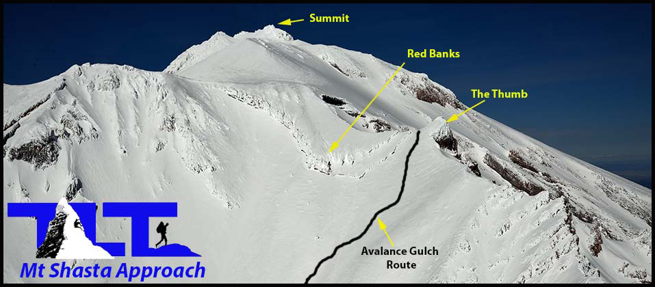
 The image above gives you a fairly clear picture of all the major landmarks on Mt Shasta.
 After Horse Camp as described in the above, paragraphs, the next goal is Lake Helen. This landmark (labeled near the center of the right hand image) is the first day goal of most people climbing the mountain.
Of course you do not have to stop at Lake Helen if you are in excellent condition and have begun your climb early enough (around 2AM or so). Some people opt for this plan and push to the summit and back without an overnight stay at Lake Helen.
But breaking the climb up into a day or more is a good way to enjoy the beauty of the mountain during different lighting conditions. And it is especially nice to be able to take a break and rest before pushing on to the summit. After Lake Helen (which is the typical High Camp for folks who do the peak in two days), comes Red Banks. The section from Lake Helen to Red Banks, is the toughest part of the climb in my opinion. Lots of elevation gain. After that comes Misery Hill, and then the Summit.
 Well, that's about it for the initial approach information on Mt Shasta. This is certainly not by any means the only way to climb Mt Shasta, and there are many other paths up the mountain (including the more technical routes up glaciers on the north side of the peak,
but the Avalanche Gulch Approach is the most popular and most widely traveled, and is the route we have chosen here. But if you are a frequent visitor to Mt Shasta and you have already climbed this route you may want to explore other possibilities. There are many good books available that will provide invaluable information on other options for climbing this particular mountain. For much more on this peak, you can go to the menu above and click on the Mt Shasta option for more links and information on climbing this mountain.
Well, that's about it for the initial approach information on Mt Shasta. This is certainly not by any means the only way to climb Mt Shasta, and there are many other paths up the mountain (including the more technical routes up glaciers on the north side of the peak,
but the Avalanche Gulch Approach is the most popular and most widely traveled, and is the route we have chosen here. But if you are a frequent visitor to Mt Shasta and you have already climbed this route you may want to explore other possibilities. There are many good books available that will provide invaluable information on other options for climbing this particular mountain. For much more on this peak, you can go to the menu above and click on the Mt Shasta option for more links and information on climbing this mountain.
Email Sign Up

| Join the Adventure! Sign up here for Timberline Trails Monthly Newsletter |

Join us on Instagram
©2006-2026 TimberlineTrails. All Rights Reserved.
....