Please Wait While Photos Load

Kings Canyon National Park timberlinetrails.net
and horse trails. The Sierra crest forms the eastern boundary of the park, from the Mount Goethe in the north, down to Junction Peak, at the
boundary with Sequoia National Park. Several well-travelled passes cross the crest into the park, including Bishop Pass, Taboose Pass, Sawmill
Pass, and Kearsarge Pass. All of these passes are above 11,000 feet (3400 m) elevation. (From Wikipedia The Free Encyclopedia)
boundary with Sequoia National Park. Several well-travelled passes cross the crest into the park, including Bishop Pass, Taboose Pass, Sawmill
Pass, and Kearsarge Pass. All of these passes are above 11,000 feet (3400 m) elevation. (From Wikipedia The Free Encyclopedia)
Goto Sierra Nevada
Home Page
Kings Canyon National
Park consists of two
sections. The small,
detached General Grant
Grove section of Kings
Canyon National Park
preserves several groves
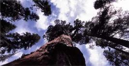
of giant sequoia including
the General Grant Grove,
with the famous General
Grant Tree, and the
Redwood Mountain
Grove, which is the
largest remaining natural
Giant Sequoia grove in
the world (covering 3100
acres (13 km²) and with
15,800 sequoia trees
over one foot (0.30 m) in
diameter at their bases).
This section of the park
is mostly mixed conifer
forest, and is readily
accessible via paved
highways.[1]
The remainder of Kings
Canyon National Park,
which comprises over
90% of the total
acreage of the park, is
located to the east of
General Grant Grove
and forms the
headwaters of the
South and Middle Forks
of the Kings River and
the South Fork of the
San Joaquin River. Both
the South and Middle
Forks of the Kings
Rivers have extensive
glacial canyons. One
portion of the South
Fork canyon, known as
the Kings Canyon, gives
the entire park its name.
Kings Canyon is a
4,000 foot (1,2 km)
deep canyon carved by
glaciers out of granite.
The Kings Canyon, and
its developed area,
Cedar Grove, is the
only portion of the main
part of the park that is
accessible by motor
vehicle. Both the Kings
Canyon, and its Middle
Fork twin, Tehipite
Valley, are glacial
“Yosemites” – deeply
incised glacial gorges
with relatively flat floors
and towering granite
cliffs thousands of feet
high. [1]
Cloud Canyon, in the
park's backcountryTo
the east of the canyons
are the high peaks of
the Sierra Crest
culminating in 14,242
foot high North
Palisade, the highest
point in the park. This is
classic high Sierra
country – barren alpine
ridges and glacially
scoured lake-filled
basins. Usually snow
free only from late June
until late October, the
high country is
accessible only via foot
Home Page
Kings Canyon National
Park consists of two
sections. The small,
detached General Grant
Grove section of Kings
Canyon National Park
preserves several groves
of giant sequoia including
the General Grant Grove,
with the famous General
Grant Tree, and the
Redwood Mountain
Grove, which is the
largest remaining natural
Giant Sequoia grove in
the world (covering 3100
acres (13 km²) and with
15,800 sequoia trees
over one foot (0.30 m) in
diameter at their bases).
This section of the park
is mostly mixed conifer
forest, and is readily
accessible via paved
highways.[1]
The remainder of Kings
Canyon National Park,
which comprises over
90% of the total
acreage of the park, is
located to the east of
General Grant Grove
and forms the
headwaters of the
South and Middle Forks
of the Kings River and
the South Fork of the
San Joaquin River. Both
the South and Middle
Forks of the Kings
Rivers have extensive
glacial canyons. One
portion of the South
Fork canyon, known as
the Kings Canyon, gives
the entire park its name.
Kings Canyon is a
4,000 foot (1,2 km)
deep canyon carved by
glaciers out of granite.
The Kings Canyon, and
its developed area,
Cedar Grove, is the
only portion of the main
part of the park that is
accessible by motor
vehicle. Both the Kings
Canyon, and its Middle
Fork twin, Tehipite
Valley, are glacial
“Yosemites” – deeply
incised glacial gorges
with relatively flat floors
and towering granite
cliffs thousands of feet
high. [1]
Cloud Canyon, in the
park's backcountryTo
the east of the canyons
are the high peaks of
the Sierra Crest
culminating in 14,242
foot high North
Palisade, the highest
point in the park. This is
classic high Sierra
country – barren alpine
ridges and glacially
scoured lake-filled
basins. Usually snow
free only from late June
until late October, the
high country is
accessible only via foot

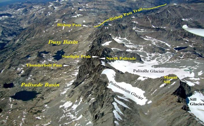
The above aerial view of the Palisade Crest along with Dusy and Palisade basins below, show a good chunk of the
alpine terrain of Kings Canyon National Park. Peaks such as North Palisade, Mount Sill, Starlight Peak, and
others on the crest top out at over 14,000 ft making this crest in Kings Canyon the highest continuous ridge in all the
Sierra Nevada Mountains. Because of this fact, many alpine climbers visit Kings Canyon coming from the Palisade
Glacier side, and cross over the crest in pursuit of an elusive peak, and do not even realize that they have just spent
some time in Kings Canyon National Park.
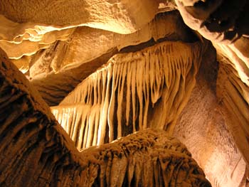
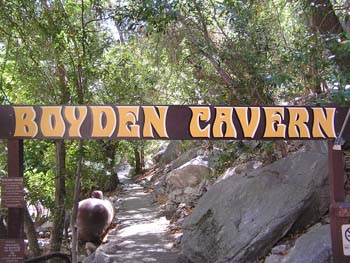
Unknown to most visitors to Kings Canyon and Sequoia National Parks, is that there are many caves beneath the
alpine territory of the parks. Boyden Cavern is one of these caves that is open to the public. Daily tours of this
interesting cave take place during the summer months.
alpine territory of the parks. Boyden Cavern is one of these caves that is open to the public. Daily tours of this
interesting cave take place during the summer months.
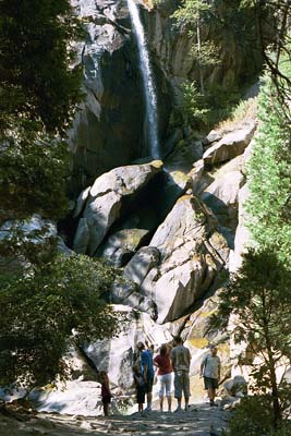
As you travel through Kings Canyon, keep
a sharp eye out for little cascading
waterfalls flowing down the canyon walls
during springtime and early summer
months. They provide for a great stopping
place for a break while traveling the parks
one way road to the bottom of the canyon.
a sharp eye out for little cascading
waterfalls flowing down the canyon walls
during springtime and early summer
months. They provide for a great stopping
place for a break while traveling the parks
one way road to the bottom of the canyon.
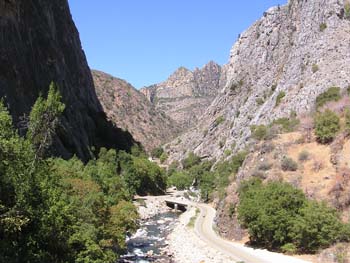
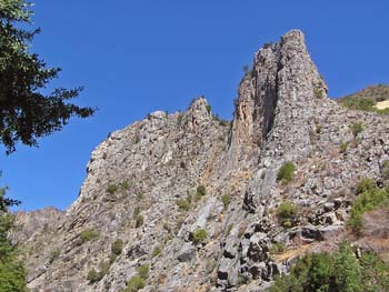
You will be surrounded by high granite walls when
traveling to the bottom of Kings Canyon.
traveling to the bottom of Kings Canyon.
This above photo shows the terrain near the bottom of
the canyon. When you get there, you will find a great
place to picnic, along with a wonderful little general store
stocked with souvenirs and goodies to eat.
the canyon. When you get there, you will find a great
place to picnic, along with a wonderful little general store
stocked with souvenirs and goodies to eat.
Photo by Glen McGluckie
Photo by Mike Koerner
from his Sail Plane
from his Sail Plane
Photo by Glen McGluckie
Photo by Glen McGluckie